Monday, June 27, 2011

A World of Photography


I've posted before about the ever expanding globe of geotagged photos.  I can see the wealth of images from around the world soon being turned into some sort of photosynth-meets-google-streetview image orgy.  Until then we can sit back, relax and anticipate.  Right?

While I've been a "pro" (meaning I pay money) member of flickr for a couple of years, I've never really used it.  I wanted to make sure I had a "cloud" to store all my photos before we started using the term "cloud".  Flickr certainly fit the bill, but until my recent full-fledged photography obsession, I never understood the flickr world.  A week of looking around has taught me much about how to use it as a tool and clued me into the wealth of knowledge it includes.

The thought of turning one's experiences into an ever-evolving digital profile is something I've thought about a lot.  I'm not talking about facebook, but more of a true fingerprint.  Lots of people have privacy concerns - but whatever.  Right at the top of the list of the cool personal experience widgets would be auto geotagged photos showing where you've been and for how long.   I see it as the more classier version of  this old blog widget. 


Today as I was perusing flickr I stumbled upon this image Courtesy of Eric Fischer

World map of geotagged pictures

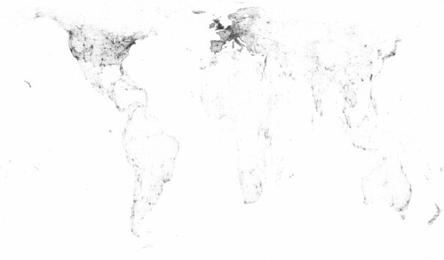
This is essentially a history of geotagged images.  The darkest is the oldest, with the lighter shades being tagged more recently.  It begs the question how many shades of grey are included.  That would be a good follow up question but I already asked one question of Eric - where did you get the data? The data was assembled from flickr and the picassa API.  What's cool is that I was pretty sure the data was from those API's.  What's frustrating is I have zero programming experience and for the time being have to live vicariously through the API-harnessing abilities of people like Mr. Fischer.

Does this map remind you of anything else?  This perhaps?

Be sure to check out the original size version on flickr.  It's a heck of a map and an incredible set of data.


Monday, June 20, 2011

LUST All Around Me

It's sad that finding 87 octane gas for $3.65 a gallon is a "nice surprise" on par with today's discovery that my change jar yielded 85 dollars.   When we become so entranced with the daily price change of oil and gasoline is a good time to examine what is included when we buy a gallon of gas.

For each gallon you pump, a penny goes into the EPA's Leaking Underground Storage Tank trust fund. The trust fund has two purposes, one, to provide money for overseeing and enforcing corrective action to clean up the leaking tank. Second, the Trust Fund provides money for cleanups at UST sites where the owner can't be determined or the corrective action cannot be enforced.

We know we use a lot of gallons of gas, and that means a large fund - we're talking 100 million per year.  But how big is the problem, really?

Today I looked up information on LUST sites in Michigan and decided to make a map.  I got the data from a state website.  Perhaps the most disturbing is how much information is missing from this spreadsheet.  Perhaps more disturbing that the sheer number of sites (there are thousands of sites leaking contaminates into the ground) is that contact information for the owner is often either non-existent or consists of something like "Charles".

Turns out it's a huge problem.  Take a look at this map of LUST sites in southeast Michigan classified as "open", which means environmental concerns remain and may worsen.


9,000

Just in Michigan.

That's a lot of little purple dots...


Monday, June 13, 2011

Searching for the Church and Finding a Filter

Being a geography nerd gives me oodles of confidence when it comes to finding my way. 

Give me a point of reference and I won't get lost.

Give me a map and I can find my way out of anywhere.

I truly can't be fooled...well, almost.

While I have a pretty good view in my head of the earth, it turns out it isn't as detailed when you get to the street level.  I was reminded of this en route to the second of what turned out to be three hotels in the greater London area on holiday two weeks back.

The Church Street Hotel describes itself as a Spanish-American oasis in Downtown South London.  It appeared to be a pretty cool alternative to our stay at Le Meridien on Piccadilly.  We should have known we were in for a longer than expected journey to our hotel on Camberwell Church Street when the Concierge at Le Meridien told us he "couldn't find our hotel on a map" - thanks for the help.  Sure it was a long journey, but it would expose us to an area of London we wouldn't otherwise see.

No worries, I say.  Who needs a map in a foreign country, a tourist?  Not me!

The tube goes as far south as Elephant and Castle.  This marked the beginning of our pedestrian journey (shown as a purple line in the map below).  Having just run a marathon a few days prior 1.6 miles doesn't seem very far, however, when you are only guessing where you are going, don't have a map, and have all of your luggage with you, 1.6 miles becomes a challenging (what turns out to be) 50 minute walk.  While Ally figured we were in the wrong location after about 25 minutes of walking, I lost faith in my ability to find our hotel just as we were exiting a small park on to Camberwell Church Street. 

Hallelujah!

It didn't help that the street name changes three times before finally intersecting with Camberwell Church Street.

Thinking each step is taking you two steps away from your final destination is a good way for a couple to get in an argument, but we did remarkably well.


We were so excited when we actually found our destination we had to take a picture of the street sign. I think it turned out quite nice.  It even has a bit of a natural vignette.


Fast fact for today - You'll find street signs on buildings in the UK rather than stand alone like we see in the US.

In the map above I've also shown the "filter exhibit" for your very own point of reference.  After walking through what felt like little French Jamaica in London to get to our hotel, we were surprised to see that we were only a few blocks away from the South London Gallery.  While walking back from the South London Gallery, which proved to be much more interesting than the gallery in Kensington Park, we stumbled upon a small, local photography exhibit, FILTER - a lens based exhibition, advertised by 8.5 x 11 sheets of paper stuck to the ground and sides of buildings. 
While the exhibit was a "meh", finding the gallery in a fledgling art-incubating neighborhood proved to be one of the most interesting, organic experiences of the trip. It also gave us new appreciate for a little known Place, tucked away in Southwark.

And here's a parting shot of the entrance. 


Monday, June 6, 2011

...And All I Got Was This Stupid Bus Pass

One of the rewarding parts of vacationing is the ability to distance oneself from work.  While I was able to escape the day-to-day stressors that accrete between vacations, transportation and transportation funding were underlying themes of my experience.

The streets of Edinburgh were bustling with activity, from tourists to bankers to local kids wearing Super Dry clothes.  Even though the town is relatively compact, the preferred method of travel by almost everyone is bus transit, not because they are all euro-hippies, but because it is so unbelievably convenient.  Lothian Buses were ubiquitous.  Most places it seemed there were as many double decker buses as their were automobiles.  The places where auto traffic was not allowed were still busy with double decker buses avoiding signs indicating the current project to add a high capacity tram in the city. 

Lothian buses allowed us to go anywhere in the city, quickly and affordably.  A single ride was a little more than a pound, a day pass was 3 pounds 20 but a week long pass was only 16 pounds.  Just think - 25 bucks to be chauffeured around all week, 23 hours a day.

The 3 pounds I had to pay for the physical Lothian bus pass provided me with a great souvenir.


And here is a picture of me near Waverly station, picking up the wifi signal from an airlink bus.  Airlink is a service offered by Lothian providing buses to and from the airport (about a 25 minute drive) every 8 minutes.  Remarkable convenience.  


While not everyone knows of the Lothian buses in Edinburgh, most everyone knows of London's tube.   I learned a lot more about the tube in London this time around.  I had no idea it went all the way out to Heathrow.  This would have come in handy instead of having to pay the 50 bucks or whatever it was I paid to ride the Heathrow express on 20 March, 2009 (of course that offered a small souvenir too).


I learned before the trip of the Oyster cards which, if you have one, provide approximately half price fares (along with unbelievably helpful information to transport planners over there).  After learning that Oyster cards were only five pounds, I knew I had to get my own, even though Ally's brother gave us two to use for the trip. 

Five pounds later I had a smile on my face, as I owned my very own Oyster card...

Saved Photos-140
...with fricken Will and Kate on it. Ugh.