Monday, November 14, 2011

Big City Lights

I spent the weekend in Chicago two weeks ago. It was a short trip, only two days. It was enough for me to catch the big-city-life bug again. The place we stayed was right downtown, within walking distance of just about everything. It was 15 minutes one way to the Hancock and 25 to the Museum district, Soldier Field area. In fact, it was right here:
View Hotel de Andy in a larger map
The ability to walk to so many attractions, food venues, and artistic happenings made me very jealous. I love my house but I simply don't have the ability to go places, and more importantly do THINGS without a car. I have a nice path to go running on but I'm a straight, three mile jaunt away from exciting stuff, like a bookstore - a real LIVE bookstore. I think that is where they tell you how to use a Nook.

More than JUST density, comprehensive public transportation is critical to a lively community. While there were more cars than I remember in Chicago, bus, bike or walk are clearly the way to go. I live in Washtenaw County, where we are on the verge (well a year away) of a historic vote on the future of transit service in our area. I suppose I could walk to these attractions, but three miles each way adds up. And nobody likes a sweaty runner in a bookstore (is that an old saying?). With expanded service I might have the chance to catch a ride on the bus for that 3 mile straight shot, putting me right in the heart of a corridor ripe for redevelopment and investment. It seems like attracting young twenty something talent like myself would be a good tool for further development. Ah crap, I'm thirty-something now. Guess I'll have to start watching that show.

The transit provider in the area has spent considerable resources over the past year or two promoting its Transit Master Plan. Now we're to the point where, as a community, we need to see if we are "forward-thinking" enough to expand to a more comprehensive countywide transit system - you know, like the ones they have in every major city, Detroit, in some ways, excepted. What's best is a public involvement tool being used to gather comments from the community. Check it out here. Ah yes, GIS is everywhere.

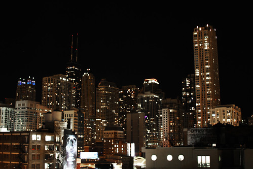
And for good measure, here's a picture of the big city lights that have me itching for an urban lifestyle. night sky

Monday, November 7, 2011

Zombie Apocalypse in Phillipines

You've probably heard of the effect where, if you're pregnant, you'll notice pregnant people everywhere, taking over the earth.

It turns out the same happens with new websites coming online.

While this one is my "pride and joy" I'm always starting some new blog or website.  Ten days or so ago, I started a couple websites with a friend on zombies.  That's right, zombies- everything zombies.  Wouldn't you know, as soon as we made that decision, I've heard Zombie discussion everyday.  It's popping up EVERY day in conversation.  Sure, some of that is the Halloween peak, but a lot of it is because general zombie-talk is on the rise.  Check out this infograph from Google insights.

We haven't clearly figured out the entire form, flow or function of the web sites, but part of the reason to do all of this is that the web, despite its obvious thirst for zombie info, does not have many quality sites.

OK, anyway.

Interestingly enough, I know nothing about zombies, and for someone who technically operates three zombie websites, that's a tad embarrassing.  So I spent some time doing some high level research.  The most interesting thing I noticed was the intense geographic hot spots of zombie search activity.   

Who knew that the zombie search term was so popular in the Philippines?  I'm amazed at its popularity throughout the southeast Asia area.  And...I'm looking forward to learning more about why that is...because the world deserves good zombie sites.


 Check out the whole zombie report here.

And since I figure you wonder, two of the sites are www.killthezombie.com and www.savethezombie.com


Monday, October 31, 2011

Leaving on a Jet Plane...

I've been fortunate to do a fair amount of international travel over the past few years.  This past week I booked a trip for March of 2012 in the Czech Republic.  Once again I'll be participating in a run, although a half marathon this time, the Hervis Half Marathon. The course looks amazing, for the most part hugging the Vltava river. 

So hopefully the trip will mirror what I was able to do in London and Scotland.
westminster Picture 036 Arthur's Seat

Take a look around at our hotel and where we'll be staying
View Larger Map
 
Also exciting is the fact that we'll be right across the river from the Dancing House.

Yes, photographic opportunity everywhere.

I'd love to hear your stories if you've been to the Czech Republic.  Feel free to post a comment.

Monday, October 24, 2011

Update Yourself on Africa

Africa has been in the news a lot in the past couple of weeks.  Sure, the biggest story is the death of Gaddafi, but the news wire is buzzing with major events all over the continent.  As I've mentioned before, you should keep yourself up to date on these current events, because they impact us, and will continue to impact us and our foreign policy for years to come.

For social issues perhaps the biggest story is Morgan Tsvangirai's about-face on gay rights.  Gay rights is a really hot topic across Africa, particularly because of the harsh punishments, including death to the openly gay.  Not only has the Zimbabwean Prime Minister changed his tune, but he is referring to sexual choice as a human right.  Now, if we could only get rid of the nemesis, Mugabe.

Earlier today there were two bombings in Nairobi, Kenya, one at a bar and one at a bus stop.  This is particularly concerning because they come just days after threats from al-Shabab, the al Qaeda linked terrorist extremists.  The group has had a strong hold on much of Somalia, including Mogadishu but an African alliance of troops has recently made significant gains in the area.  In fact, they've almost completely forced al-Shabab from Mogadishu.

And we recently heard the US was sending a small cadre of troops into Uganda to fight the Lord's Resistance Army.  The LRA are a scary bunch of brainwashed central Africans led by a mad man.  I was unaware of the extent of their terrorist reign over the region.  I came across a fantastic website that you should visit LRACrisisTracker.org.  These folks are doing amazing work assembling critical information and attempting to spread the word.

Take a look at one of their videos. It's powerful stuff


Monday, October 17, 2011

ESRI Uses Preemptive Strike Against Google Earth Builder

A few months ago, the GIS world went gaga over Google's announcement that they were moving into the professional realm of GIS with Google Earth Builder.  The thought of Google competing directly with the big dog - ESRI was exciting.  I could almost hear the prices falling. 

Google Earth Builder is attempting to merge cloud computing and GIS functionality.  A mix appealing to government and non-profit agencies - a market ESRI has had a strangle hold on.  They wowed us with this teaser video.


With a history of making GIS so simple and accessible, it seemed  that Google was making a statement - thank you for holding the reigns, but we got it from here!

That might have been a bit premature.

I don't talk much about ESRI products on this blog BECAUSE they are not as simple and accessible as Google products.  That appears to be changing thanks to ArcGIS Online.

"Maps and Apps for Everyone" - that's the first thing on their website.  ESRI has made map making, hosting and sharing free. Up to 2GB of free storage are granted simply by registering an ESRI global account, which takes about a minute. Once you have that account you can leverage thousands of available layers, upload OR create your own from scratch. Once you've created maps you can add them to a gallery and share them all around the world. ESRI has taken things one step farther by providing website templates that can be used to showcase your map galleries right in your own web domain.

And they didn't stop there. They have added single click web app publishing. That means you can create webpages and maps for use on any mobile device instantly. This is more than just something that will open on an iPad, we're talking about templates built to work across multiple mobile technologies.

The point is, ESRI is attempting to bring GIS data to everyone. It's free and it's easy!

So far, me like!

Monday, October 3, 2011

Secondary Data

Tomorrow I'm speaking as a guest at an Urban Planning class at Eastern Michigan University. I've been asked to speak about secondary data and how it relates to my job and the jobs of other transportation planners. As I was assembling a list of topics and sources it dawned on me that a few of these might work well for readers of this blog.

Remember the Census long form? I bet you were glad you didn't get one as part of the 2010 census! How do I know that? There is no census long form anymore. It's been replaced by annual data collections that are packaged into 1, 3 and 5 year data sets. We now call it the American Community Survey. I suppose the thought is that if you call it that, people won't realize it's sort of just the census long form. This means your odds of having to answer the in depth questions of what used to be the census long form are less during the full census count, but higher during any other year.

It's taken the folks at the Census a while to get this data packaged appropriately but the factfinder2 website is finally working fairly reliably.  From there you can access just about any information you'd like, depending on the size of your community.  If your community is larger than 60,000 you can get the 1 year data sample, but if you live in a rural area, you'll need to rely on the 5 year data.  The feds are quick to say it's NOT a five year average but rather, a representation of the five year period.  Tomorrow we'll be looking at means of transportation to work by age.

Whatever.

Unlike the Census, the Center for Neighborhood Technology (CNT) mashes up tons of data into ways that help planners.  Our office started keeping them on our radar about a year or so ago.  My favorite mash up is a household and transportation affordability index which puts together household costs and transportation costs as a percentage of income.  We refer to this visualization as the "drive to qualify" map because, despite being approved for mortgages in suburban areas, an alarmingly high number of people spend more than 45% of their income on household and transport expenses.  With a percentage that high, there isn't a lot left to support this "creative class" we pride ourselves here in Southeast Michigan.  Check it out in more detail by clicking below.  You can start here and zoom right into your own community.


H+T Affordability Index: Ann Arbor, MI: Comparing Housing Costs - % Income to Housing and Transportation Costs - % Income

The Housing + Transportation Affordability Index is an innovative tool that measures the true affordability of housing based on its location.
© Copyright 2003-10 Center for Neighborhood Technology
2125 W North Ave, Chicago, IL 60647 · Tel: (773) 278-4800 · Fax: (773) 278-3840

And now, you don't have to go to class tomorrow!