
A few years ago, the general lack of geographic mastery of many Americans became front page news after this now famous answer regarding Americans' inability to locate the US on a world map.
Notwithstanding the hilarity of the poor girl's misfortunate answer, we should remind ourselves of the question. "Recent polls show 1/5 of Americans can't find the US on a world map. Why do you think this is?"
In many ways, Ms. Teen South Carolina might not have been too far off with her main point - we need more MAPS.
Realizing that this is a serious issue, I wanted to learn about groups promoting geography as a discipline and not just a map quiz (as much as I enjoy those). Geography is so much more than being able to find Mauritania on a map and we need to promote it as such! A web search brought me to an amazing initiative from National Geographic (who else?) called my wonderful world.
The site is full of shocking statistics from the Roper study about our (Americans) lack of geographic knowledge. Did you know only 19% of kids have a world map? (It's no wonder nobody knows about Eritrea.) Half of young Americans can't find New York on a map and half of high school principals think their geography tools are inadequate (although I haven't heard a kid mention French West Africa myself) and only 37% of young Americans can find Iraq on a world map. These stats are staggering! I know it's easy to make these results worse than they really are by tweaking the questions and the way they are asked but the underlying issue remains clear: Geography is not our strong suit and to a great extent we think we are alone in the world.
I'd be very interested to see the Roper study, which was the basis for the epic Ms. Teen USA question, administered in other countries around the world. I think we'd find an extremely high correlation between investment and achievement but I bet there are very few countries who adequately invest in their geography curriculums. That's a problem. It's time for "US Americans" to step up the plate. Help spread the word. Go to My Wonderful World and pledge your support today.
Remember, as the Discovery Channel taught us, the world is just awesome!
Boom-de-a-da, boom-de-a-da, boom-de-a-da...I love that song!
Sunday, June 27, 2010
Monday, June 21, 2010
Choose Your Own African Adventure
Flying to Africa is expensive. But where are the least expensive places to fly in the continent?
As I search for the location of my next adventure I decided to check on the cost of flights in a given week from Detroit to all the African capitals to see if there was anything fascinating and worth mentioning. There certainly are some surprises; It also provides some information for people looking at the relative cost of travel to various African states.
Ever since I discovered kayak.com I've been doing numerous searches for deals on flights to Africa. (I use the term "deal" very loosely). After hundreds of searches I've learned a few things I thought I'd share with you.
1. Prices to Africa fluctuate significantly. I've seen prices go up and down well over $1,000 per week.
2. In general, buying tickets around 5 months in advance provides the lowest average price.
3. Thursday departures from the US seem to result in the lowest fares. My default, first search is a Thursday US departure and a following Saturday departure from my destination. In my Kayak account I use the three days before and after for both, but that never seems to make it much cheaper.
4. If you're comfortable with the price don't wait too long for nickel and diming. This is especially true if you are 4 months or less from departure. There is often a dramatic increase around this time that I wouldn't want to be caught in. (Last minute flights can easily get to 7,000 dollars.)
5. Set alerts from kayak.com on your travel dates to keep track of the price movement. Also, use their calendar to see fluctuations in best price fares at different times of the upcoming year and in months past. Keep in mind this isn't always possible since there aren't a whole lot of inquiries into flight pairings such as Detroit to Luanda.
For this project I picked November 4 and November 11 as travel dates from and to Detroit Metro Airport (DTW). I used kayak's flexible schedule with three days before and after, but as I said, this doesn't seem to alter prices noticeably.
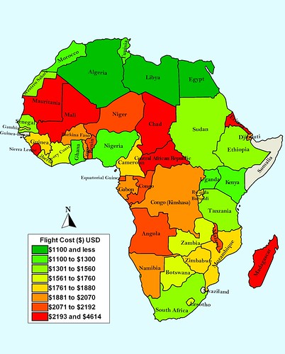
I find it fascinating that the most inexpensive countries to travel to border the most expensive. Further, the fact that Libya's Tripoli was the lowest at $1,059 is interesting in itself.
The surprise on the expensive side has to be Mauritania. With the exception of Rabat in Morocco and Laayoune (which I used in place of a Capital for Western Sahara) Nouakchott is the closest destination for most of the US. However, Mauritania comes in at 6th highest with round trip airfare costing 2,337. Notably, Mauritania comes in right in front of Madagascar (2371) despite the nearly 5,000 additional miles needed to fly to Antananarivo. I've included all the results at the bottom of this post. Does anything unexpected jump out at you? Have you had any great flight deals?
Like this map? Check out previous nerd projects on:
Twitter and Africa
Google and Africa
Perceived US-African Relationship This one may need an update! :)
Here is a list of the actual results:
Sierra Leone 4,614
Eritrea 3,085
Chad 2,449
Central Africa Republic 2,424
Madagascar 2,371
Mauritania 2,337
Mali 2,195
Congo (Brazzaville) 2,190
Angola 2,178
Equatorial Guinea 2,124
Niger 2,109
Benin 2,087
Malawi 2,071
Togo 2,069
Burkina Faso 2,012
Djibouti 2,004
Gabon 2,000
DRC 1,972
Namibia 1,899
Rwanda 1,845
Zimbabwe 1,838
Burundi 1,838
Mozambique 1,823
Guinea 1,798
Cameroon 1,771
Gambia 1,759
Lesotho 1,745
Botswana 1,713
Liberia 1,694
Ivory Coast 1,627
Zambia 1,573
Western Sahara (Laayoune) 1,534
Tanzania 1,376
Ethiopia 1,363
Senegal 1,339
South Africa 1,322
Sudan 1,308
Ghana 1,255
Kenya 1,248
Uganda 1,201
Tunisia 1,139
Morocco 1,137
Nigeria 1,101
Algeria 1,089
Egypt 1,075
Libya 1,059
No flights to:
Swaziland
Somalia
Guinea Bissau
As I search for the location of my next adventure I decided to check on the cost of flights in a given week from Detroit to all the African capitals to see if there was anything fascinating and worth mentioning. There certainly are some surprises; It also provides some information for people looking at the relative cost of travel to various African states.
Ever since I discovered kayak.com I've been doing numerous searches for deals on flights to Africa. (I use the term "deal" very loosely). After hundreds of searches I've learned a few things I thought I'd share with you.
1. Prices to Africa fluctuate significantly. I've seen prices go up and down well over $1,000 per week.
2. In general, buying tickets around 5 months in advance provides the lowest average price.
3. Thursday departures from the US seem to result in the lowest fares. My default, first search is a Thursday US departure and a following Saturday departure from my destination. In my Kayak account I use the three days before and after for both, but that never seems to make it much cheaper.
4. If you're comfortable with the price don't wait too long for nickel and diming. This is especially true if you are 4 months or less from departure. There is often a dramatic increase around this time that I wouldn't want to be caught in. (Last minute flights can easily get to 7,000 dollars.)
5. Set alerts from kayak.com on your travel dates to keep track of the price movement. Also, use their calendar to see fluctuations in best price fares at different times of the upcoming year and in months past. Keep in mind this isn't always possible since there aren't a whole lot of inquiries into flight pairings such as Detroit to Luanda.
For this project I picked November 4 and November 11 as travel dates from and to Detroit Metro Airport (DTW). I used kayak's flexible schedule with three days before and after, but as I said, this doesn't seem to alter prices noticeably.
I find it fascinating that the most inexpensive countries to travel to border the most expensive. Further, the fact that Libya's Tripoli was the lowest at $1,059 is interesting in itself.
The surprise on the expensive side has to be Mauritania. With the exception of Rabat in Morocco and Laayoune (which I used in place of a Capital for Western Sahara) Nouakchott is the closest destination for most of the US. However, Mauritania comes in at 6th highest with round trip airfare costing 2,337. Notably, Mauritania comes in right in front of Madagascar (2371) despite the nearly 5,000 additional miles needed to fly to Antananarivo. I've included all the results at the bottom of this post. Does anything unexpected jump out at you? Have you had any great flight deals?
Like this map? Check out previous nerd projects on:
Twitter and Africa
Google and Africa
Perceived US-African Relationship This one may need an update! :)
Here is a list of the actual results:
Sierra Leone 4,614
Eritrea 3,085
Chad 2,449
Central Africa Republic 2,424
Madagascar 2,371
Mauritania 2,337
Mali 2,195
Congo (Brazzaville) 2,190
Angola 2,178
Equatorial Guinea 2,124
Niger 2,109
Benin 2,087
Malawi 2,071
Togo 2,069
Burkina Faso 2,012
Djibouti 2,004
Gabon 2,000
DRC 1,972
Namibia 1,899
Rwanda 1,845
Zimbabwe 1,838
Burundi 1,838
Mozambique 1,823
Guinea 1,798
Cameroon 1,771
Gambia 1,759
Lesotho 1,745
Botswana 1,713
Liberia 1,694
Ivory Coast 1,627
Zambia 1,573
Western Sahara (Laayoune) 1,534
Tanzania 1,376
Ethiopia 1,363
Senegal 1,339
South Africa 1,322
Sudan 1,308
Ghana 1,255
Kenya 1,248
Uganda 1,201
Tunisia 1,139
Morocco 1,137
Nigeria 1,101
Algeria 1,089
Egypt 1,075
Libya 1,059
No flights to:
Swaziland
Somalia
Guinea Bissau
Thursday, June 17, 2010
Google Earth on the iPad
Well over a month after iPads hit stores in the US, the folks at Google have finally released an update to the Google Earth application, including native support for the iPad.
It's about damn time.
Previously the only way to use GE on the iPad was using the iPhone app and the pixel doubler. While it's nice that, as Apple puts it, you can choose from over 200,000 iPhone and iPod touch apps in the App Store, iPad owners know the pixel doubler was basically to allow the promotion of the "over 200,000 apps" pitch. This was painfully apparent with the iPhone Google Earth app. The LatLong blog even said "Some iPad users have noticed that Google Earth has been available for the iPad from the very beginning, but until today, this has simply been the iPhone version running in a scaled-up mode." HA!
Now Google Earth is available in much of its glory on the iPad. The layers are the same available from version 2 of the iPhone GE app with the addition of roads as shown below.

The settings button allows easy toggling of the auto-tilt feature which seems to work much better on the iPad. The user gets the sense of picking up a window on the world. As this update will likely be the last one before iPhone 4, I wonder if there will be additional auto-tilt functionality given the addition of a gyroscope. Side-to-side tilt would really add to the user-experience on the iPad, we'll first have to see if it works on the iPhone.

Overall Google Earth works swimmingly on the iPad, but I do have a few complaints and reservations. I don't understand why the Google Earth functionality can't be added in to the Google Maps application. Satellite imagery is already there, add the ability to sign in to your maps account, add more layers and zoom out to globe (as an option) and you've virtually elimnated the need for the Google Earth app all together. Also, there are a couple of bugs that come with signing in with ones maps account. The Google servers see the application as a third party and do not recognize it. That's not too bad in itself but it is a little silly when Google doesn't recognize itself as "Google Earth". I'm assuming this silly little quirk will be fixed in the next update.

Another frustration is that the panoramio icons don't appear in the Google Earth iPad app until the user is zoomed in much farther than in it's PC counterpart. As someone who uses this layer quite a bit exploring exotic areas all over the wolrd, it's sometimes difficult to know where imagery is available.
I was also really hoping to be able to load, create and record tours. I think the iOS would provide a very immersive tour creation platform. Alas, that is relegated to the wish list.
Overall its a vast improvement over the previous release as far as the iPad is concerned but if the functionality could simply be added to the Google Maps application, standard on the iPad, the more streamlined product would likely be better utilized.
Update:
Check out my video review on Youtube:
Monday, June 14, 2010
Reflections on Namibia and the Across the Divide Marathon
It's been two weeks since I returned from Namibia. While in Country I participated in Across the Divide's Namibia Marathon in the Namib Desert.
Running is new to me. I only started running after I signed up for the Namibia Marathon in the second half of 2009. The thought was to go on a destination marathon. After how much time I spent counting the minutes until my Tanzania trip in 2009 I thought having the "distraction" of training for a marathon would be good for me. I had no idea what to expect in my training; I figured that even if I had to crawl, I'd finish. Finishing was the goal, a return to Africa was the treat.
With a few Google searches along the lines of "Marathon in Africa" I came to the Across the Divide Namibia Marathon page. A Marathon in the desert...cool! It turns out ATD has Google to thank for more than a few participants of the Namibia Marathon and Ultra Marathon.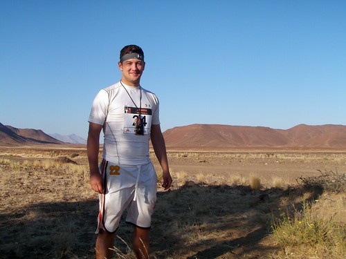
The couch to 5k is a proven program. The couch to desert marathon is...untested. Training started well but as my runs got longer I began to struggle with injuries. In addition to an illness which took me off the track for two weeks, hip flexor issues, shin splints and IT band syndrome nearly stopped me in my tracks.
By the time the trip was here I felt unprepared. I was comfortable with my level of commitment throughout my training but I felt another month would have helped a lot. I would have to make due with my fitness.
The race was a fantastic experience and the participants were an indescribable bunch. I finished in six and a half hours, well within the 8 hour cut off. I learned a lot about hydration, electrolytes and my body after struggling with the worst cramping of my life. Having ones legs seize up every 20 meters for about 3 hours is a heck of an experience and one that made me feel even better about my accomplishment.
Leading up to the race it seemed that the biggest challenge for the race would be the heat but that couldn't be further from reality- for me. With temperatures exceeding 100 degrees it's certainly an issue but for me the thought "it's hot" only crossed my mind a few times. Earlier on in the worst heat of the day I was fortunate to overpower those thoughts with ones of "there is no way you're not finishing this". The big surprise and the biggest challenge was the terrain. I was under the impression that the track would be relatively solid under foot. While a good portion of the race, especially early on is solid there are spots where you are running through several inches of sand...one might as well be running on a sand dune. In addition to the sand there was fine gravel which sucked the energy out of each step just as the sand. There were even a few small rock formations we had to climb over.
My Garmin etrex Vista HCx GPS was great for the race and lasted through the sand, dirt, spilled water and accidental tosses. It did its job superbly and after 26.2 (well apparently 26.7)miles my treat is this display of the route.

So I returned with a great sense of accomplishment and a renewed passion for the motherland. Africa is an amazing and expansive place. If Tanzania taught me the former, Namibia taught me the latter. The vastness is indescribable.
And now I enter an exciting time: The search for the next adventure. The world is at my fingertips, and all I have to do is point and select.
Thursday, June 10, 2010
National Geographic iPad App Video Review
I'm tired of people bashing the new National Geographic app for the iPad. Sure, there are a few ways the app could be improved but in general it is a great tool for viewing the best paper maps in the world.
Below is my video review of this misunderstood and under appreciated iPad application.
That all being said, it's been months NatGeo, time to get a few of the bugs fixed!
Below is my video review of this misunderstood and under appreciated iPad application.
That all being said, it's been months NatGeo, time to get a few of the bugs fixed!
The Geography Blog
Apparently my love of maps is not shared by many. Niche shops and niche bloggers are out there but with few exceptions one cannot mention their affinity for maps without a look of confusion trickling across the face of the listener.
Maps represent tangible places and experiences. When I was a kid I would look for simple geographic features, like the curving of a coastline or the bending of a road and try to find that feature on a map. I thought about the technology and thought that must go into map making and how refined maps had become compared to their mid-millennium counterparts. I was also a strange kid :)
Now I spend a good portion of my life making maps. For the most part they are simple with a narrow and somewhat boring purpose but I'm hoping to change that. Geography, maps and imagery is my true passion. It's a way to make sense and capture moments in an ever changing and beautiful landscape.
Geography lets us keep our physical place on this planet and in the universe in perspective. It allows us to relate to each other in a multitude of geospatial and cultural ways. It makes us human.
On this blog, I'll run the gamut from google earth to maps, general geography and did you knows, how to's and new technology. I hope you enjoy it as much as I like experiencing it!
Let's get started!
Subscribe to:
Posts (Atom)


