Friday, September 24, 2010

Popularity of Google in Africa

The World Wide Web resembles its moniker more and more each day. While the Internet has spread quickly in western countries, its roll out has been much slower in other areas of the world, especially Africa. Fortunately, global Internet giants like Google are able to take advantage of some of the expanding African web infrastructure provided by companies like SEACOM.

Each country is assigned a Top Level Domain (TLD) by the Internet Assigned Numbers Authority. You're probably most familiar with TLD country codes like .us for the United States and .uk for the United Kingdom. What you might not know is that your favorite link shortener bit.ly uses the Libyan TLD .ly.

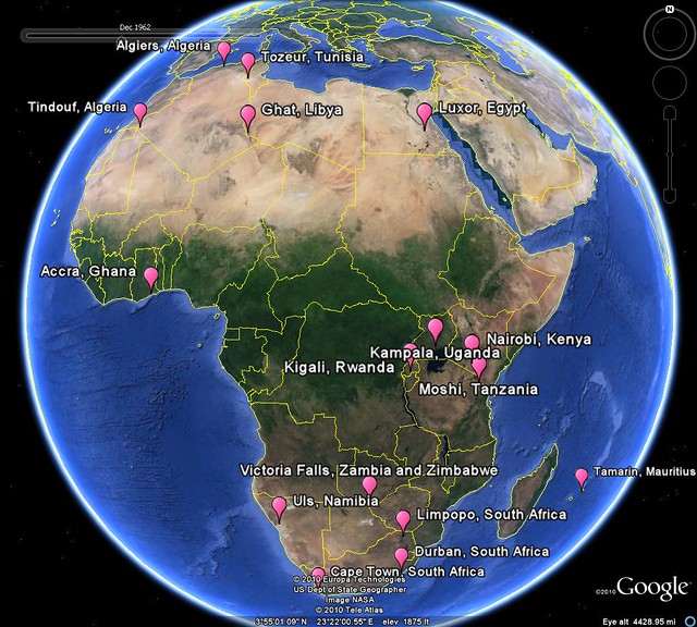
Google, in their infinite wisdom, wealth and power have provided customized Google search pages for almost all the countries in the world. I decided to look at the popularity of the African TLD Google pages. I was able to find pages for almost every African country. Often, the extension includes .co before the country code such as www.google.co.bw for Botswana.

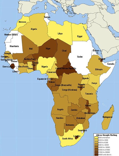
I used Alexa, the Internet traffic reporting site, to get the site rank for each Google country TLD available. I've included the results a few different ways. First, the map below breaks down countries into eight categories based on the Alexa rankings. The African countries rank between the 138th most viewed site on the Internet, Google Egypt, and number 524,835, Google Central African Republic. At last check Worldgeoblog.com was in the 5 millions ;) I've also included links to each of the sites that are ranked below the map. Last, I'm providing the kml file which includes Country Name, Alexa rank and URL.

Africa Google Alexa Ranking

Algeria
Angola
Benin
Botswana
Burkina Faso
Burundi
Cameroon
Cape Verde
Central African Republic
Chad
Comoros
Congo (Brazzaville)
Congo (Kinshasa)
Côte d'Ivoire
Djibouti
Egypt
Equatorial Guinea
Eritrea
Ethiopia
Gabon
Gambia
Ghana
Guinea
Guinea-Bissau
Kenya
Lesotho
Liberia
Libya
Madagascar
Malawi
Mali
Mauritania
Mauritius
Morocco
Mozambique
Namibia
Niger
Nigeria
Rwanda
Sao Tome and Principe
Senegal
Seychelles
Sierra Leone
Somalia
Somaliland
South Africa
Sudan
Swaziland
Tanzania
Togo
Tunisia
Uganda
Western Sahara
Zambia
Zimbabwe

Wednesday, September 22, 2010

The Old Man in the Prince of Wales Pub

I had been in London for about 5 hours, intentionally trying to get lost and had more or less succeeded when I happened upon a little old pub in Chelsea. Satisfied that it was time for a pint, I walked up the steps of the Prince of Wales pub at the corner of Old Brompton Road and Empress Place. I tried to open both of the entryway doors to no avail. Just as I turned around to find another pub, and old man, whom I hadn't yet noticed told me that it would only be a moment or so before the pub opened. I'm sure he used a much more whimsical and creative phrase but it has since escaped me.

Shortly after, the doors were opened and the old man and I walked in. I found a seat at a table by myself and ordered from the bartender who was doubling as my waiter. After a few minutes and half of my first pint I wandered over to the old man who was sitting a few tables over. Eager to engage in a conversation with a Brit, I told him how impressed I was with the little bar and we engaged in some great chit chat.

The man had some serious health issues. Probably in his 70's, he had difficulty walking and spoke with a soft voice. I was still trying to get a sense of Londoners and wondering what they thought of me. After speaking a little bit about our respective countries' interest in "football" the man provided me with some insight into his existence. He said that his doctor had told him that if he didn't quit drinking and smoking he would die. To that, he told me. "This, this fag I can live with out but I'll be damned if I don't die with a pint in my hand". It was a simple quote but one that was more endearing than you can imagine.

For me this little anecdote sort of encapsulated my London experience, especially because all of my pictures were deleted. While most trips have pictures, this one is only memories. My adventure in London is now all in my head. I'll never forget that bar, nor the old man who sat outside with me waiting for it to open.

Because all of my pictures were deleted it was important to me to find the pub where I had such a fond memory. When I returned home I took it upon myself to find my favorite London pub. Despite walking around the city, lost, for just shy of 11 hours, I had a fairly good idea of where I had gone and I didn't think it would be hard to find. This goes to show that with a good sense of an areas geography and direction it's hard to ever really be lost. I recognized many of the places I went while I looked around London in Google Earth. I knew the pub was near Brompton Cemetery which, despite forgetting the name (as was the case with the pub) was easy to find. I looked everywhere to the north and the east but couldn't find my pub!

It was more than a year later before I happened upon the Prince of Wales pub in Chelsea in Google Earth just to the southwest of the cemetery. I've included a picture from Google Earth Street View below.

Prince of Wales Pub

It's a very special place, very far away. I hope you get the opportunity to go there someday.

I enjoy hearing other peoples stories about travels. The personal side to trips are usually the most interesting to read about. I encourage you to write stories of your own travels on your blog. Be sure to let me know by leaving a comment. Check out some great take aways of Catholicgauze's trip to Saudi Arabia.

Tuesday, September 21, 2010

The Failed States Index 2006 to 2010

Each year the Fund for Peace and Foreign Policy provide us with a fascinating look at the state of the States using the Failed States Index (FSI). The index is created from scores of 12 categories divided into social, economic and political indicators. The worst possible score on the index is 120, a truly failed State. The best score possible, 12, is some sort of unimaginable paradise. States are given a score and based on that score, given a status of either sustainable, moderate, warning or alert.

While surfing the internet looking for discussion of the FSI rankings I found that much more attention is given to the rank of States on the index rather than their score. This is unfortunate because the real power in the failed states index is the in-depth analysis and score. It's also a great way to examine the overall direction of a State. These are not arbitrary numbers assigned to each category based on minimal research. Each category for each State is researched as extensively as possible. As such, the score is much more important than the rank.

I took scores from the 2006 Failed States Index and 2010 Failed States Index to look at the change over that 4 year period. While the index dates back to 2005, the scores were not as extensive and a lot of data was unavailable. The 2006 data (and select data from 2007) provides a much better point of comparison to the 2010 data. Realisitcally, four years isn't enough time to fairly evaluate an administration or regime with this deep an analysis. Fixing a failed state takes time. Still, examining the failed states index over even a short period of time provides insight into a country and even the state of the world.

Below is the map I made showing the change in score from 2006 to 2010. Note that the negative values reflect a better score, this is to say green represents those States which have improved the most while red shows those who are moving away from order.

Change in Failed States Index with legend

If you're interested I've made the KML file available here.

I've listed 161 States in rank order of FSI score change from 2006 to 2010. South Africa has had the greatest change in the wrong direction from 55.7 in 2006 to 67.9 in 2010. The last, Montenegro improved its score from 83.8 in 2006 to 57.3 in 2010 however it should be noted that the 2006 ranking is for both Serbia and Montenegro. The FSI score of Serbia improved to 77.8 in 2010.

1 South Africa
2 Kenya
3 Guinea-Bissau
4 Niger
5 Italy
6 Lebanon
7 Afghanistan
8 Eritrea
9 Central African Republic
10 India
11 Iceland
12 Senegal
13 Somalia
14 Iran
15 Georgia
16 Belgium
17 Philippines
18 Chad
19 Cameroon
20 Mozambique
21 Ethiopia
22 Ghana
23 Gambia
24 Spain
25 Madagascar
26 Guinea
27 Chile
28 Benin
29 Nigeria
30 Australia
31 Israel
32 Argentina
33 Oman
34 Greece
35 Canada
36 Mali
37 Equatorial Guinea
38 New Zealand
39 Zambia
40 Brazil
41 Singapore
42 Thailand
43 Malawi
44 Namibia
45 Ireland
46 Cambodia
47 Algeria
48 Yemen
49 Hungary
50 Japan
51 Sri Lanka
52 Honduras
53 Malaysia
54 Switzerland
55 Uganda
56 Mexico
57 Burma
58 Tanzania
59 Sweden
60 Turkey
61 Armenia
62 Azerbaijan
63 Mauritius
64 Costa Rica
65 Tunisia
66 Bolivia
67 El Salvador
68 Norway
69 Bahrain
70 Gabon
71 Mongolia
72 Botswana
73 Djibouti
74 Tajikistan
75 Swaziland
76 South Korea
77 Zimbabwe
78 Mauritania
79 Moldova
80 Poland
81 Finland
82 Austria
83 Burkina Faso
84 Lesotho
85 Laos
86 Kazakhstan
87 United Arab Emirates
88 United States
89 Kuwait
90 Jamaica
91 France
92 Libya
93 North Korea
94 China
95 Ecuador
96 Morocco
97 Portugal
98 Saudi Arabia
99 Nicaragua
100 Paraguay
101 Uruguay
102 Burundi
103 Nepal
104 Jordan
105 Congo (Kinshasa)
106 Bangladesh
107 Togo
108 Netherlands
109 Guyana
110 Estonia
111 Malta
112 Czech Republic
113 Panama
114 United Kingdom
115 Sudan
116 Congo (Brazzaville)
117 Pakistan
118 Bhutan
119 Syria
120 Papua New Guinea
121 Slovenia
122 Luxembourg
123 Latvia
124 Bulgaria
125 Belize
126 Slovakia
127 Suriname
128 Albania
129 Iraq
130 Qatar
131 Kyrgyzstan
132 Denmark
133 Egypt
134 Lithuania
135 Vietnam
136 Peru
137 Macedonia
138 Romania
139 Cuba
140 Venezuela
141 Cyprus
142 Croatia
143 Haiti
144 Sierra Leone
145 Guatemala
146 Ukraine
147 Colombia
148 Turkmenistan
149 Uzbekistan
150 Rwanda
151 Germany
152 Angola
153 Bosnia and Herzegovina
154 Belarus
155 Serbia and Montenegro
156 Indonesia
157 Liberia
158 Côte d'Ivoire
159 Russia
160 Dominican Republic
161 Montenegro

Monday, September 20, 2010

Urban Transport: Detroit and Nouakchott

Vast amounts of developable land, capitalism and access to fast moving personal transportation is a potent mix for sprawl, a phenomenon as American as baseball, apple pie or high fructose corn syrup.

While the invention of the automobile was a huge factor in fostering an emerging middle class, it greatly increased the ability of people to travel farther on a daily basis. Living within walking distance of a grocery store or work was no longer a necessity. Eventually people moved farther out from the cores of older cities until suburbs became "town" for many.

As Americans became increasingly reliant on their automobiles, more roads were built to support more traffic. The cost of maintaining a quickly expanding infrastructure was dwarfed by the economic power and expansion afforded by the middle class, by now by far the largest class and arguably the most powerful. The enormous investment by the federal government in the interstate system continued to expand the infrastructure at an astonishing rate while at the same time hiding the true cost of a system which provided so much freedom.

The cycle more or less repeated itself until one of the first true realizations of non-sustainable development occurred. Building new road infrastructure induced vehicle travel. As the interstate system continued to gouge at the countryside it was apparent that change was needed.

Most large communities saw mass transit as a way to, if nothing else, hedge their bet on road investment. Today we see that investment has largely paid off as the successful metropolitan areas have fully funded and well utilized public transit systems.

These investments have encouraged reurbanization and densification by allowing people to live near the places they eat, work and recreate without the burden of a car. It takes time for this paradigm regression to happen. So long that many systems fail because they are not given ample opportunity to grow and perform the functions for which they were designed.

Far be it from the majority of Americans, myself included, to give up their personal, climate controlled transport pods. Even if a switch occurs towards increased funding of mass transit systems, the majority of the tens of billions of federal transportation dollars each year will continue to go to roads. The difference now is that relatively few dollars are being spent on expansion of the road system. Instead, urban and transportation planners are choosing to invest in maintenance of the existing system and creative solutions to the problems that plague it such as safety and congestion.

A two-birds-with-one-stone approach is the modern roundabout. A far cry from the high speed traffic circles of old, modern roundabouts allow greater flow of traffic through an intersection while reducing the frequency and severity of crashes. When put in that context they sound too good to be true. One area that has been slow to the roundabout party is Detroit. Yes, the same metropolis that gave us the car, suffered from central city flight and has chronically underfunded it's public transit system.

Perhaps one of the most unexpected discoveries of my travels is that some of the poorest and most undeveloped countries in the world fully invest in their road infrastructure and provide extensive subsidies for public transit, a true necessity.

In that spirit, I've included an image I found of a roundabout in Nouakchott, Mauritania. The reasons for installing a roundabout at this intersection are different from the issues affecting a city like Detroit but the irony is very real, and for geography lovers, fascinating.

Mauritania roundabout

Wednesday, September 15, 2010

16 Marathons in Africa to Get Your Heart Pumping

Destination marathons are a great way to travel. Instead of simply counting down the days until your vacation, run and cross-train the time away. You'll end up in great shape just in time to enjoy some amazing places. With its deserts, jungles, mountains and beaches, Africa is a great place to consider for your own destination marathon.

To help you decide where to go I've assembled a list, map, and information on 16 marathons in Africa. If one of them catches your interest or you'd like more information click on the appropriate link below the map.

If you know of other marathons in Africa, leave a comment. If you've completed a destination marathon, or are planning one, let me know your story. Leave a comment here or better yet, write a post on your own blog. I'd love to hear about it!

Happy running!

africa marathon

Accra, Ghana
Luxor, Egypt
Tozeur, Tunisia
Tindouf, Algeria
Kigali, Rwanda
Moshi, Tanzania
Limpopo Province, South Africa
Durban, South Africa
Algiers, Algeria
Cape Town, South Africa
Tamarin, Mauritius
Namibia
Nairobi, Kenya
Zambia and Zimbabwe
Kampala, Uganda
Ghat, Libya


The lead up to my marathon:

In 2009 I decided to start training for a marathon. I had tossed around the idea of a destination marathon for some time and realized the time to act was now. A few years earlier I had come across the Christmas Island marathon, and this was where I started my internet searches. I was immediately intrigued at the thought of running around a small island in the Indian Ocean and the prospect of flying through Sydney or perhaps Kuala Lumpur.

Unfortunately, I couldn't find any information on a 2010 Christmas Island marathon. A few more searches revealed the Namibia marathon through Across the Divide. I've already written a post about my experience in Namibia.

Two things have happened since I returned from Namibia:

1. The marathon bug bit me again
2. My last treatment failed to remove the Africa bug

Time for more research!

Monday, September 13, 2010

Socotra and Thoughts of Island Paradises

"Island paradise" evokes different images for different people. For me, it's the intriguing, intertwined landscapes of the islands of Seychelles. For others it's the cascading mountains and lush greens of Hawaii. There is something romantic about the thought of being stranded on a desert island, focusing on oneself and ones survival instead of the every day hustle and bustle of modern life. Robinson Crusoe, who had well documented issues on his own island paradise said "...I looked back upon my desolate, solitary island as the most pleasant place in the world and all the happiness my heart could wish for was to be but there again." Remarkably, our wonderful world is dotted with a plethora of these "pleasant places".

Socotra is a lesser-known island paradise. Near the intersection of the Gulf of Aden, the Arabian Sea and the Indian Ocean, the archipelago offers a host of endemic species. Socotra offers an ecosystem arguably more unique than the Galapagos due to it's multi-million year move away from its Gondwanaland roots.

The beautiful Yemeni archipelago has a young and budding tourism industry. Much of the areas allure is because it remains relatively untouched and unique, not an overbuilt tourist trap. However, to emerge as a legitimate and significant industry, certain amenities and investment need to occur. The government of Yemen faces the challenge of finding the delicate balance between development and preservation. Before a clear path is taken, Socotra struggles with a bit of an identity crisis. Although, with as varied a cultural history as it has, perhaps its ability to evolve while maintaining its natural wonder is the true identity of the archipelago.

Not surprisingly a debate continues as to how Yemen should administer the area. Should it remain largely a preserve or should the government promote tourism on its tropical gem? I found an editorial which argues Socotra is more beautiful than Hawaii and should be developed. I'm not so sure. I'm in the camp that believes the real draw is the relatively pristine and unique ecosystem. At the very least it's an interesting take.

And here is your image of the week, the main island of Socotra. What do you think? Should it be developed, preserved, or a little of both.

socotra

With the recent addition of daily air service from the Yemeni mainland, Socotra has what it takes to be a real player in the eco-tourism market. It's far away, beautiful, safe, accessibly and exotic.

So where is YOUR island paradise?

The basement geographer beat me to the punch on this post. He includes a lot more information on his post on Socotra and some of its native species. Be sure to check him out.

Friday, September 10, 2010

Australia and the 24th Parallel

Being the WORLD Geo Blog, I reckon it's high time we have a post involving Australia, mate. Growing up, my thoughts of Australia most often involved kangaroos, Paul Hogan and the Coriolis effect, although not all at once. The latter was mostly because I realized how very far from down under I existed. Beginning with the miracle of the World Book Encyclopedia and culminating with panoramio photos in Google Earth, my views of Australia have expanded and matured, like a Laphroaig 30. ;)

While this doesn't qualify as a full blown nerd project like my last post on Twitter, inspired by Catholicgauze, it's still a fun way to visualize data!

My experience to this point with the Google Earth terrain profile was limited to testing running paths, cities or perhaps small mountains or lakes. Always looking for extremes, I went ahead and drew a much longer path today, 2,400 miles, in across Australia. I chose the 24th parallel because, well, that's where my mouse pointer first clicked. My thought was to find something significant about the parallel. Unfortunately, the southern 24th parallel is the Cooper Manning of parallels- never gaining the notoriety of its bigger brothers, the Tropics of Cancer and Capricorn and dabbling on the edge of forgotten-paralleldom.

Below is a screen shot which shows the 24th parallel drawn across the Australian continent as well as its terrain. Never reaching more than 2600 ft with an average slope of about .2% Australia is the flattest continent. A fascinating continent, though, and one which will be the subject of posts to come on World Geo Blog.

Australia 24th parallel
For more detail, click on the image above.

In case you were wondering, yes, that is Membata marked by the blue anchor. :)

16 Marathons in Africa to Get Your Heart Pumping

Destination marathons are a great way to travel. Instead of simply counting down the days, run and cross-train the time away. You'll end up in great shape just in time to enjoy some amazing places on your trip. With its deserts, jungles, mountains and beaches, Africa is a great place to consider for your own destination marathon.

To help you decide where to go for your destination marathon I've assembled a list, map, and information on 16 marathons in Africa. If one of them catches your interest or you'd like more information click on the appropriate link below the map.

If you know of other marathons in Africa, leave a comment. And if you've completed a destination marathon, or are planning one, let me know your story, either with a comment or a post on your own blog. I'd love to hear about it!

Enjoy!

africa marathon

Accra, Ghana
Luxor, Egypt
Tozeur, Tunisia
Tindouf, Algeria
Kigali, Rwanda
Moshi, Tanzania
Limpopo Province, South Africa
Durban, South Africa
Algiers, Algeria
Cape Town, South Africa
Tamarin, Mauritius
Namibia
Nairobi, Kenya
Zambia and Zimbabwe
Kampala, Uganda
Ghat, Libya


The lead up to my marathon:

In 2009 I decided to start training for a marathon. I had tossed around the idea of a destination marathon for some time and realized the time to act was now. A few years earlier I had come across the Christmas Island marathon, and this was where I started my internet searches. I was immediately intrigued at the thought of running around a small island in the Indian Ocean and the prospect of flying through Sydney or perhaps Kuala Lumpur.

Unfortunately, I couldn't find any information on a 2010 Christmas Island marathon. A few more searches revealed the Namibia marathon through Across the Divide. I've already written a post about my experience in Namibia.

Two things have happened since I returned from Namibia:

1. The marathon bug bit me again
2. My last treatment failed to remove the Africa bug

Time for more research!

Wednesday, September 8, 2010

Twitter Followers of World Leaders Mapped

A few days ago, Geographic Travels made a post about world leaders on twitter. I have a real love-hate relationship with twitter. Twitter offers a world of possibilities but those are only realized by a small few, myself excluded. I end up bouncing between a world of spam and one of inactivity.

So while the post on world leaders using twitter is great by itself, my geo-eye saw data - raw data that craved to be mapped! I searched how many followers each account had to see if the data held anything of particular interest. I've tried before to measure twitter popularity in an interesting yet 100% non-scientific way in a previous nerd project!

For the map below, I created a new point GIS layer and added info about how many followers each account listed. Now, don't take the scaled symbols too literally. I had to do some scaling when you have Obama at more than 5 million followers and others with barely 1,000. We can't learn much from this map- but it's still cool! I've included the data at the bottom of this post.

The unexpected outlier in this data set is Jordan and Queen Rania Al Abdullah. Although, it doesn't take much to figure out why ;) To find out for yourself, simply do a google search and follower her on twitter @QueenRania.

Twitter Followers
I mention Geographic Travels in part because they are one of the best geography blogs out there. Good blogs are hard to find and finding a good GEOGRAPHY blog is an even greater challenge.

Along with Geographic Travels, I was fortunate to be listed on the recently named 50 Best Geography Blogs for Geography Geeks. The fact that Samantha Rhodes was able to assemble this list of blogs is an accomplishment by itself. What impresses me most is that the listing actually provides a reasonable description of each blog. When I found out I was on the list I was sure that the description of my blog would be straight from my meta tags. It certainly wasn't.

Samantha provided this snippet to describe World Geo Blog "Read World Geography Blog for global news and views about the immensely intimate relationship between people and places." Its a better description than I could ever come up with and I'm thankful for the recommendation.

Go check out the 50 Best Geography Blogs and let me know what else you find!

Also check out another great geography blog I found - The Basement Geographer.

As promised...The Data!

Canada - 64,600
Chile - 195,000
Costa Rica - 1,100
Denmark - 6,100
Ecuador - 5,700
France - 5,200
Israel - 8,500
Jordan - 1,350,000
Latvia - 3,900
Malaysia - 32,500
Mexico - 110,200
New Zealand - 12,600
Norway - 33,200
Russia - 42,900
South Korea - 23,900
Thailand - 126,000
Turkey - 86,800
UAE - 349,000
UK - 1,750,000
USA - 5,300,000

Monday, September 6, 2010

Controversy Over the New Malawian Flag

A flag says a lot about a country. I challenge you to find a color, shape or image placed haphazardly on one. Flags tell a story, and ofter a glimpse of a country's history. But while flags are a source of pride to many, they can symbolize hatred for others.

This was the case in the state of South Carolina, the scene of a row (this is an attempt to use a British idiom - how'd I do?) in 2000 between supporters of the Confederate flag, who saw it as a symbol of state pride and those who opposed it, citing it as an embodiment of racism at the highest level of state government. More recently the old Gadsden flag (shown below) has been take up by the tea party in its infancy as a symbol of conservative ideologies. Whatever your political views, what a flag represents evokes strong feelings for those who fly it.

GadsdenFlag

While in the scheme of history, flags change frequently. The flags of the world carry a certain sense of permanence with them. For this reason it's important we, as geographers and students of the world, take notice when a flag, and therefore a country, undergoes a major change.

Malawian President Bingu wa Mutharika "successfully" implemented a new national flag at the end of July. Mutharika claims that the fully exposed sun "reflect(s) the modern Malawi" and adds that Malawians should be happy about the changes implemented because "Malawi is developed and it is still developing compared to the colonial era". The new flag is shown on the left below, the old flag on the right.


While this seems noble and positive on the surface, its implementation has been extremely controversial. Comments written in English on the Nyasa Times articles about the new flag show a strong stance against the new flag.

Despite Mutharika's claims, Malawi still has a long way to go to attain true economic competitiveness. Malawi ranks 28th on Foreign Policy's failed States index, two higher than Eritrea. The costs of replacing flags is high and it is even illegal to display the country's old flag. The government should be focusing resources towards economic growth and the well-being of it's citizens. Instead, they are wasting money to make unsubstantiated claims about development that cannot be backed up. They are in fact spending money to cover up where their policies have failed.

Sunday, September 5, 2010

South American Economic Gem: Chile and its Mines

With the juxtaposition of deep water trenches to the west and the Andes mountains on the east, Chile is one of the most geographically and geologically enigmatic places in South America. Spanning nearly 40 degrees of latitude, the country is ten times longer than its widest east to west point. What really makes it shine is its rare display of economic prowess outside of North America and Europe, oil powers like Equatorial Guinea excepted. Chile has forged strong foreign ties all over the earth strengthening its status as a South American economic gem. I myself contribute to its economy through frequent purchases of Chilean wine!

This success is related to its natural resources and ability to mine, process export and responsibly trade. Chile is truly the copper capital of the world, producing about a third of the earth's copper. Just more than a month ago, the world saw some of the forgotten costs of mining when a mine collapsed in Copiapó trapping 33 miners. Those miners remain trapped and it could be months before they are rescued. Today I learned that the mining company that owns the San Jose gold and copper mine is filing papers for bankruptcy. Let's hope the actions of the owners are not as sinister as they appear.

US news agencies widely reports the location of the San Jose mine as "north of Copiapó" or in "northern Chile". I wanted to see what a large gold and copper mine looked like from above. My first search on Google Earth was fruitless but falling back on the good old Google search engine I was able to find the location of the mine at GoGeometry.

The first image is a close up of the San Jose mine. The second shows its location relative to the City of Copiapó.


I find it interesting that the mine, which extracts tons of resources from inside the earth, resembles a scar on the earth's crust.


This isn't Chile's first experience with a long-term rescue. The Associated Press published a great story on survivors of the 1972 plane crash in the Andes carrying the Uruguay rugby team speaking to the trapped miners. While the circumstances are quite different, I think that hearing from someone who has been through such a strenuous ordeal will help.