
The idea is to go from Alicante, Spain to Cape Town, South Africa on a sail boat as fast as possible. Not having their own database companies and billions in disposable income, most people instead flock to a game to simulate the long race. I'm always intrigued by visualizations of a massive number of data points.
Of course those databases companies make both the real race possible and amazing geographic visualizations to go with it, such as the one below.
The track of each person that participated is shown in white, with a tiny blue dot showing the position of each boat.
Perhaps the coolest part is noticing things like the people who didn't follow through and sail straight into North America, or those who tried to use the Suez canal and sail around the horn of Africa rather than the western coast.
Whatever their reasons, its cool to look at the thoughts and strategies of so many people in just 30 short seconds!
Monday, December 19, 2011
Monday, December 12, 2011
Strait
It's incredibly frustrating to fork over hundreds of dollars a month for gas. Being addicted to gas is not fun. There's no way out - you can't live without it. You can put it off for a day, hoping the price will go down and you can drive miles searching for the best dealer, but in the end, you have to get gas.
A side effect of that addiction is a heightened sense of Middle East sociopolitical awareness for most Americans. Recently, we saw the significant impact of the Arab Spring in Libya on the price of oil. This was quite interesting because Libya has a relatively small share of world oil production. We're so addicted, though, that we use it as fast as our dealers can produce it.
And then we "lost" a drone in Iran.
They we're not impressed. And, as they do from time to time brought out the threat of blocking the Strait of Hormuz. Now, I had heard of this threat but looked a little further into the potential implication of having the straight closed.

It turns out, more than 40% of oil shipped by tanker in the world passes through the straight of Hormuz. That means 15 million barrels per day - give or take a few.
Looking back at my post on oil production by country we see that that can be thought of as Saudi Arabia and Iran going off line at the same time. That's the number two and four producer in the world. Libya is about 17th.
So unfortunately that couple hundred dollars a month could look very cheap in 2012.
And that's not fun to think about.
Monday, December 5, 2011
Brain Drain
From time to time, events in one's everyday work life will lead that person to evaluate their continued service. It's at that time that I, er, one, considers the possibility of moving somewhere else, somewhere to a place where they feel their needs will be better met.
I've been down that road before, and to a certain extent, for almost everyone, its a continuing evaluation. In southeast Michigan we have an interesting problem. We have great universities and a below average economy. That manifests itself as significant brain-drain, where the talented folk move outside of the area.
Washtenaw County (think Ann Arbor) attracts lots of people (the young ones) from all over the region, who then get a great education financed in part by the taxpayers. A frustratingly high number of those people go out of state seeking the fruits of a less-bad economy. This makes our economy even worse, with the exception of the night before thanksgiving when everyone comes back to go out to the bars and fellow-high-school-alumni-watch.
Wayne County (think Detroit) has an even bigger problem, a dwindling population. Unfortunately it's a rarity for a well-educated Detroiter to stay put in the city.
So we know these issues are there but Forbes just came out with a great tool to visualize it. Using tax data it shows how many people move between counties, net gain in blue, net loss in red. Unfortunately I can't embed the cool tool. But here are links to the Washtenaw County and Wayne County maps. It'll take a minute to load...but be patient, it's worth it.
Wayne County
Washtenaw County
Monday, November 21, 2011
A Prime Slice Before Thanksgiving
Just a few days away from Thanksgiving, it's time to take a look at a little slice of the earth. The Prime Meridian is the ugly step child of the equator. It's the go to longitudinal line, unappreciated for no other reason than our perception of up and down in the universe.
Ultimately the reason for this post is my frustration with Google's decision to not allow exports of the great elevation profiles in Google Earth. I realize they own a certain amount of the "rights" to it, but at the same time, it seems like one of those things you shouldn't be able to own, you know, the moon, earth elevation profiles...Antarctica.
I took a slice on near the Prime Meridian (give or take a couple minutes each way) starting on the north shore of the UK and extending to the southern shore of Ghana. I guess I think this elevation profile is cool because, when dealing with such a long line, you can really "see" things. Starting with the relatively flat lands over England, extending to the Pyrenees near the border of France and Spain (and Andorra), we then see the fall off into the Mediterranean which jumps up to the Algerian edge of the Atlas mountains and finally falling off across the Sahara and across the ol' Volta.
 So that's one way of looking at it...here's another:
 Simple, yes...but still pretty cool.
Ultimately the reason for this post is my frustration with Google's decision to not allow exports of the great elevation profiles in Google Earth. I realize they own a certain amount of the "rights" to it, but at the same time, it seems like one of those things you shouldn't be able to own, you know, the moon, earth elevation profiles...Antarctica.
I took a slice on near the Prime Meridian (give or take a couple minutes each way) starting on the north shore of the UK and extending to the southern shore of Ghana. I guess I think this elevation profile is cool because, when dealing with such a long line, you can really "see" things. Starting with the relatively flat lands over England, extending to the Pyrenees near the border of France and Spain (and Andorra), we then see the fall off into the Mediterranean which jumps up to the Algerian edge of the Atlas mountains and finally falling off across the Sahara and across the ol' Volta.


Monday, November 14, 2011
Big City Lights
I spent the weekend in Chicago two weeks ago. It was a short trip, only two days. It was enough for me to catch the big-city-life bug again. The place we stayed was right downtown, within walking distance of just about everything. It was 15 minutes one way to the Hancock and 25 to the Museum district, Soldier Field area. In fact, it was right here:
View Hotel de Andy in a larger map
The ability to walk to so many attractions, food venues, and artistic happenings made me very jealous. I love my house but I simply don't have the ability to go places, and more importantly do THINGS without a car. I have a nice path to go running on but I'm a straight, three mile jaunt away from exciting stuff, like a bookstore - a real LIVE bookstore. I think that is where they tell you how to use a Nook.
More than JUST density, comprehensive public transportation is critical to a lively community. While there were more cars than I remember in Chicago, bus, bike or walk are clearly the way to go. I live in Washtenaw County, where we are on the verge (well a year away) of a historic vote on the future of transit service in our area. I suppose I could walk to these attractions, but three miles each way adds up. And nobody likes a sweaty runner in a bookstore (is that an old saying?). With expanded service I might have the chance to catch a ride on the bus for that 3 mile straight shot, putting me right in the heart of a corridor ripe for redevelopment and investment. It seems like attracting young twenty something talent like myself would be a good tool for further development. Ah crap, I'm thirty-something now. Guess I'll have to start watching that show.
The transit provider in the area has spent considerable resources over the past year or two promoting its Transit Master Plan. Now we're to the point where, as a community, we need to see if we are "forward-thinking" enough to expand to a more comprehensive countywide transit system - you know, like the ones they have in every major city, Detroit, in some ways, excepted. What's best is a public involvement tool being used to gather comments from the community. Check it out here. Ah yes, GIS is everywhere.
And for good measure, here's a picture of the big city lights that have me itching for an urban lifestyle.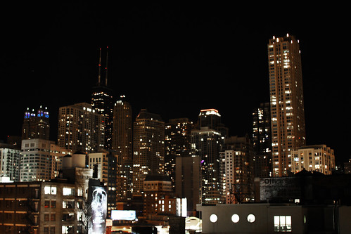
Monday, November 7, 2011
Zombie Apocalypse in Phillipines
You've probably heard of the effect where, if you're pregnant, you'll notice pregnant people everywhere, taking over the earth.
It turns out the same happens with new websites coming online.
While this one is my "pride and joy" I'm always starting some new blog or website. Ten days or so ago, I started a couple websites with a friend on zombies. That's right, zombies- everything zombies. Wouldn't you know, as soon as we made that decision, I've heard Zombie discussion everyday. It's popping up EVERY day in conversation. Sure, some of that is the Halloween peak, but a lot of it is because general zombie-talk is on the rise. Check out this infograph from Google insights.
We haven't clearly figured out the entire form, flow or function of the web sites, but part of the reason to do all of this is that the web, despite its obvious thirst for zombie info, does not have many quality sites.
OK, anyway.
Interestingly enough, I know nothing about zombies, and for someone who technically operates three zombie websites, that's a tad embarrassing. So I spent some time doing some high level research. The most interesting thing I noticed was the intense geographic hot spots of zombie search activity.
Who knew that the zombie search term was so popular in the Philippines? I'm amazed at its popularity throughout the southeast Asia area. And...I'm looking forward to learning more about why that is...because the world deserves good zombie sites.

Check out the whole zombie report here.
And since I figure you wonder, two of the sites are www.killthezombie.com and www.savethezombie.com
Monday, October 31, 2011
Leaving on a Jet Plane...
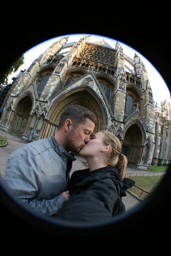
I've been fortunate to do a fair amount of international travel over the past few years. This past week I booked a trip for March of 2012 in the Czech Republic. Once again I'll be participating in a run, although a half marathon this time, the Hervis Half Marathon. The course looks amazing, for the most part hugging the Vltava river.
So hopefully the trip will mirror what I was able to do in London and Scotland.
Take a look around at our hotel and where we'll be staying
View Larger Map
Also exciting is the fact that we'll be right across the river from the Dancing House.
Yes, photographic opportunity everywhere.
I'd love to hear your stories if you've been to the Czech Republic. Feel free to post a comment.
Monday, October 24, 2011
Update Yourself on Africa
Africa has been in the news a lot in the past couple of weeks. Sure, the biggest story is the death of Gaddafi, but the news wire is buzzing with major events all over the continent. As I've mentioned before, you should keep yourself up to date on these current events, because they impact us, and will continue to impact us and our foreign policy for years to come.
For social issues perhaps the biggest story is Morgan Tsvangirai's about-face on gay rights. Gay rights is a really hot topic across Africa, particularly because of the harsh punishments, including death to the openly gay. Not only has the Zimbabwean Prime Minister changed his tune, but he is referring to sexual choice as a human right. Now, if we could only get rid of the nemesis, Mugabe.
Earlier today there were two bombings in Nairobi, Kenya, one at a bar and one at a bus stop. This is particularly concerning because they come just days after threats from al-Shabab, the al Qaeda linked terrorist extremists. The group has had a strong hold on much of Somalia, including Mogadishu but an African alliance of troops has recently made significant gains in the area. In fact, they've almost completely forced al-Shabab from Mogadishu.
And we recently heard the US was sending a small cadre of troops into Uganda to fight the Lord's Resistance Army. The LRA are a scary bunch of brainwashed central Africans led by a mad man. I was unaware of the extent of their terrorist reign over the region. I came across a fantastic website that you should visit LRACrisisTracker.org. These folks are doing amazing work assembling critical information and attempting to spread the word.
Take a look at one of their videos. It's powerful stuff
Monday, October 17, 2011
ESRI Uses Preemptive Strike Against Google Earth Builder
A few months ago, the GIS world went gaga over Google's announcement that they were moving into the professional realm of GIS with Google Earth Builder. The thought of Google competing directly with the big dog - ESRI was exciting. I could almost hear the prices falling.
Google Earth Builder is attempting to merge cloud computing and GIS functionality. A mix appealing to government and non-profit agencies - a market ESRI has had a strangle hold on. They wowed us with this teaser video.
With a history of making GIS so simple and accessible, it seemed that Google was making a statement - thank you for holding the reigns, but we got it from here!
That might have been a bit premature.
I don't talk much about ESRI products on this blog BECAUSE they are not as simple and accessible as Google products. That appears to be changing thanks to ArcGIS Online.
"Maps and Apps for Everyone" - that's the first thing on their website. ESRI has made map making, hosting and sharing free. Up to 2GB of free storage are granted simply by registering an ESRI global account, which takes about a minute. Once you have that account you can leverage thousands of available layers, upload OR create your own from scratch. Once you've created maps you can add them to a gallery and share them all around the world. ESRI has taken things one step farther by providing website templates that can be used to showcase your map galleries right in your own web domain.
And they didn't stop there. They have added single click web app publishing. That means you can create webpages and maps for use on any mobile device instantly. This is more than just something that will open on an iPad, we're talking about templates built to work across multiple mobile technologies.
The point is, ESRI is attempting to bring GIS data to everyone. It's free and it's easy!
So far, me like!
Monday, October 3, 2011
Secondary Data
Tomorrow I'm speaking as a guest at an Urban Planning class at Eastern Michigan University. I've been asked to speak about secondary data and how it relates to my job and the jobs of other transportation planners. As I was assembling a list of topics and sources it dawned on me that a few of these might work well for readers of this blog.
Remember the Census long form? I bet you were glad you didn't get one as part of the 2010 census! How do I know that? There is no census long form anymore. It's been replaced by annual data collections that are packaged into 1, 3 and 5 year data sets. We now call it the American Community Survey. I suppose the thought is that if you call it that, people won't realize it's sort of just the census long form. This means your odds of having to answer the in depth questions of what used to be the census long form are less during the full census count, but higher during any other year.
It's taken the folks at the Census a while to get this data packaged appropriately but the factfinder2 website is finally working fairly reliably. From there you can access just about any information you'd like, depending on the size of your community. If your community is larger than 60,000 you can get the 1 year data sample, but if you live in a rural area, you'll need to rely on the 5 year data. The feds are quick to say it's NOT a five year average but rather, a representation of the five year period. Tomorrow we'll be looking at means of transportation to work by age.
Whatever.
Unlike the Census, the Center for Neighborhood Technology (CNT) mashes up tons of data into ways that help planners. Our office started keeping them on our radar about a year or so ago. My favorite mash up is a household and transportation affordability index which puts together household costs and transportation costs as a percentage of income. We refer to this visualization as the "drive to qualify" map because, despite being approved for mortgages in suburban areas, an alarmingly high number of people spend more than 45% of their income on household and transport expenses. With a percentage that high, there isn't a lot left to support this "creative class" we pride ourselves here in Southeast Michigan. Check it out in more detail by clicking below. You can start here and zoom right into your own community.
And now, you don't have to go to class tomorrow!
Remember the Census long form? I bet you were glad you didn't get one as part of the 2010 census! How do I know that? There is no census long form anymore. It's been replaced by annual data collections that are packaged into 1, 3 and 5 year data sets. We now call it the American Community Survey. I suppose the thought is that if you call it that, people won't realize it's sort of just the census long form. This means your odds of having to answer the in depth questions of what used to be the census long form are less during the full census count, but higher during any other year.
It's taken the folks at the Census a while to get this data packaged appropriately but the factfinder2 website is finally working fairly reliably. From there you can access just about any information you'd like, depending on the size of your community. If your community is larger than 60,000 you can get the 1 year data sample, but if you live in a rural area, you'll need to rely on the 5 year data. The feds are quick to say it's NOT a five year average but rather, a representation of the five year period. Tomorrow we'll be looking at means of transportation to work by age.
Whatever.
Unlike the Census, the Center for Neighborhood Technology (CNT) mashes up tons of data into ways that help planners. Our office started keeping them on our radar about a year or so ago. My favorite mash up is a household and transportation affordability index which puts together household costs and transportation costs as a percentage of income. We refer to this visualization as the "drive to qualify" map because, despite being approved for mortgages in suburban areas, an alarmingly high number of people spend more than 45% of their income on household and transport expenses. With a percentage that high, there isn't a lot left to support this "creative class" we pride ourselves here in Southeast Michigan. Check it out in more detail by clicking below. You can start here and zoom right into your own community.
 | | H+T Affordability Index: Ann Arbor, MI: Comparing Housing Costs - % Income to Housing and Transportation Costs - % Income
The Housing + Transportation Affordability Index is an innovative tool that measures the true affordability of housing based on its location.
|
© Copyright 2003-10 Center for Neighborhood Technology
2125 W North Ave, Chicago, IL 60647 · Tel: (773) 278-4800 · Fax: (773) 278-3840
2125 W North Ave, Chicago, IL 60647 · Tel: (773) 278-4800 · Fax: (773) 278-3840
And now, you don't have to go to class tomorrow!
Monday, September 26, 2011
Monday, September 19, 2011
Red Borders No More
I generally avoid simple geo-news regurgitating on this blog. I want this to be a component of the interweb that explores things and their impact on people and place rather than something you can find in a thousand different places. On occasion, the poignant issues to me and the things you can find in a thousand places cross, and today's post is an example of that. Having said that, if you haven't heard about the attack at a bar in Bujumbura, google it. So few of us ever hear about stuff like this and that's a travesty. I feel it's incumbent upon me to encourage people to learn more on their own. It makes me wish I was back in seventh grade discussing current events.
It's official, South Sudan has come to Google Earth. Gone are the days of a red line border. In the eyes of Google Earth it's a bona fide yellow border country. I was quite pleased by this news. We've all been following the quest for independence and as trivial as gaining full recognition on Google Earth may seem, to me it's an awfully big deal.
Here is a picture as it appears today

And here is the article as posted on the Google lat long Blog.
Google continues to excel in Africa, both in bringing information in and working to educate people on Google's products. How cool would it be to be invited to one of these?
Monday, September 12, 2011
Finding Pommern in Rural Tanzania
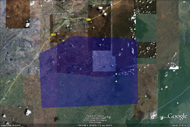
It took a while, but I finally discovered Pommern in the Kiloli District of Iringa in Tanzania. Even though I had developed a specific search area, I didn't have a very good way of methodically eliminating areas. I came across a building that appeared to be the secondary school I worked in, but the lay of the paths and roads and other buildings didn't match up. The building, however, provided me a point of reference so I could zoom out a little further and still be able to find a building of similar size. When I finally did stumble upon the Village, I couldn't believe it.
After years of looking...boom, there it is. Unfortunately, it falls outside of the area with the really nice new imagery, but it is clear enough that I was able to mark a couple key sites on my trip. It goes without saying (but not without mentioning) that this will be great for geotagging pictures. I'll be able to add many within 50 feet or so, which is amazing for extremely rural Africa. I also hope that someone who has or is planning to go to Pommern with Global Volunteers will be able to use this as a resource. I know I would have appreciated this.
So here it is. It doesn't look like much, but for me it's endless stories and memories. Certainly worth all the effort to find it.
 In case you'd like to look around and see exactly where it is, you can use this map.
View Larger Map
Yea....I need to get back.
After years of looking...boom, there it is. Unfortunately, it falls outside of the area with the really nice new imagery, but it is clear enough that I was able to mark a couple key sites on my trip. It goes without saying (but not without mentioning) that this will be great for geotagging pictures. I'll be able to add many within 50 feet or so, which is amazing for extremely rural Africa. I also hope that someone who has or is planning to go to Pommern with Global Volunteers will be able to use this as a resource. I know I would have appreciated this.
So here it is. It doesn't look like much, but for me it's endless stories and memories. Certainly worth all the effort to find it.

View Larger Map
Yea....I need to get back.
Tuesday, August 30, 2011
A Weeklong Search Party for Pommern, Tanzania
After returning home from Tanzania in 2009, I quickly took to Google Earth only to be disappointed by the fact that the image quality was poor and I couldn't pinpoint my location. The resolution was so poor I couldn't even find the Village of Pommern.
Even a few years removed from my trip I have a pretty good mental map of the area. When I returned home I estimated the location based on blurry images of maps, estimated travel times, and the turns I remembered on our ride from Iringa to Pommern. I thought I was close, but the imagery was so bad that I had no way of knowing. Now I've lost that Google place mark and so it's like starting from scratch.
This weekend I discovered that the majority of the Iringa Region in Tanzania has new, clear, crisp imagery for a large area.
Up to this point it has been unbelievably difficult to locate the village. While the other village in Tanzania associated with Global Volunteers (Ipalamwa) shows up, Pommern never has. Given that I was teaching geography and computers in Pommern it's frustrating that it's nearly impossible to locate the village in Google Earth. Although it's not as if there is internet in Pommern. For that you need to go to Iringa, where the chicken is much smoother.
I found a Facebook Group that said the secondary school, which I worked at, is 58KM from Iringa. I'm inclined to believe that distance is via the road network. Going out 58KM as the crow flies would lead into the adjacent Region of Morogoro.
I knew that Pommern was in the Kilolo district of Iringa, one of seven districts but I can't find any maps that show those district lines. That is particularly disappointing. I guess the internet is not yet complete.
I've challenged myself to find Pommern and locate it for others. Based on the information I've gathered I've developed a very generous search area of approximately 1,000 square miles. I'm very confident that Pommern is within the search area.
 Admittedly, this seemed like a much easier endeavor when I first drew the search area. It's sort of like being able to stumble upon my subdivision from a map of metro Detroit.
When I do find it I'll be able to greatly increase the accuracy of some geotagged photos in the area. Bonus!
It's quite a challenge but I think I have it in me and THAT means next week you can bet there will be a post and a link to all the features I've found and remembered. Hopefully it will give more of a voice and online presence to a great area, a great Place.
Even a few years removed from my trip I have a pretty good mental map of the area. When I returned home I estimated the location based on blurry images of maps, estimated travel times, and the turns I remembered on our ride from Iringa to Pommern. I thought I was close, but the imagery was so bad that I had no way of knowing. Now I've lost that Google place mark and so it's like starting from scratch.
This weekend I discovered that the majority of the Iringa Region in Tanzania has new, clear, crisp imagery for a large area.
Up to this point it has been unbelievably difficult to locate the village. While the other village in Tanzania associated with Global Volunteers (Ipalamwa) shows up, Pommern never has. Given that I was teaching geography and computers in Pommern it's frustrating that it's nearly impossible to locate the village in Google Earth. Although it's not as if there is internet in Pommern. For that you need to go to Iringa, where the chicken is much smoother.
I found a Facebook Group that said the secondary school, which I worked at, is 58KM from Iringa. I'm inclined to believe that distance is via the road network. Going out 58KM as the crow flies would lead into the adjacent Region of Morogoro.
I knew that Pommern was in the Kilolo district of Iringa, one of seven districts but I can't find any maps that show those district lines. That is particularly disappointing. I guess the internet is not yet complete.
I've challenged myself to find Pommern and locate it for others. Based on the information I've gathered I've developed a very generous search area of approximately 1,000 square miles. I'm very confident that Pommern is within the search area.
 Admittedly, this seemed like a much easier endeavor when I first drew the search area. It's sort of like being able to stumble upon my subdivision from a map of metro Detroit.
 When I do find it I'll be able to greatly increase the accuracy of some geotagged photos in the area. Bonus!
It's quite a challenge but I think I have it in me and THAT means next week you can bet there will be a post and a link to all the features I've found and remembered. Hopefully it will give more of a voice and online presence to a great area, a great Place.
Monday, August 22, 2011
Belle Isle
This weekend I took a drive to Belle Isle, the 1,000 acre mega park in the Detroit River just a couple miles from the center of downtown. It's a pretty cool place despite being a tad run down. It seems to be utilized for family reunions more than anything else, and really, that's not so bad. From time to time, the park does attract special events and even large events, such as the old (ol') course for the Detroit Grand Prix. Unfortunately, while it's a destination for many, the fact that it doesn't generate enough money to sustain itself is an issue for a city facing annual multimillion dollar deficits. Not that a park should be revenue neutral, but rather, based on the adjacent land use and its proximity to...things, it'd be hard to find an equal benefit.
Another reason that Detroit should be the studio/capstone class for any urban planning program.
View Larger Map
Even though Belle Isle is in need of a sprucing up, I can imagine the cost of upkeep is still very high. So there is the constant back and forth arguing over whether or not to charge admission to the park (or a toll for the bridge) and whether that will price people out or dramatically reduce utilization.
If you're interested, go ahead and take a peek at the recreation budget for Detroit. Belle Isle Operations account for about 1 million out of 19 million. Although in fairness to my naivety, I feel like I'm missing something in my reading of the Recreation "budget".
It's a park...parks belong to the people...It's part of being a civilized society...don't charge.
It is, however, just another example of the great things Detroit has going for it. Just think, Detroit has an island park bigger than Central Park...yea...I didn't realize that either. The potential is amazing and there is no shortage of ideas. But it sits, in more or less the same state it has been in for years. Aging.
The gem on the gem is the Conservatory. An interesting building indeed. I don't know if it's beautiful, or just art deco, or what. The lighting wasn't perfect on Saturday, but I created this from a few pictures I took on Saturday. Pretty cool, eh?
Obviously, this Detroit stuff is occupying my mind, and it's a GREAT thing to be talking about. I want to point out a great response to last weeks post. Check out the comment by Matt. Spot on. Kudos.
Another reason that Detroit should be the studio/capstone class for any urban planning program.
View Larger Map
Even though Belle Isle is in need of a sprucing up, I can imagine the cost of upkeep is still very high. So there is the constant back and forth arguing over whether or not to charge admission to the park (or a toll for the bridge) and whether that will price people out or dramatically reduce utilization.
If you're interested, go ahead and take a peek at the recreation budget for Detroit. Belle Isle Operations account for about 1 million out of 19 million. Although in fairness to my naivety, I feel like I'm missing something in my reading of the Recreation "budget".
It's a park...parks belong to the people...It's part of being a civilized society...don't charge.
It is, however, just another example of the great things Detroit has going for it. Just think, Detroit has an island park bigger than Central Park...yea...I didn't realize that either. The potential is amazing and there is no shortage of ideas. But it sits, in more or less the same state it has been in for years. Aging.
The gem on the gem is the Conservatory. An interesting building indeed. I don't know if it's beautiful, or just art deco, or what. The lighting wasn't perfect on Saturday, but I created this from a few pictures I took on Saturday. Pretty cool, eh?
 |
| Conservatory |
Obviously, this Detroit stuff is occupying my mind, and it's a GREAT thing to be talking about. I want to point out a great response to last weeks post. Check out the comment by Matt. Spot on. Kudos.
Monday, August 15, 2011
Images of Detroit
I've been writing about Detroit a lot lately, and that's because I have been thinking about it a lot. Fixing it is the enigma of the planning field. Its problems represent some of the most fundamental ones facing US cities today. I did go back this weekend to take some pictures of Detroit and I've included a few of them here. It's still a great city with a lot going on, but I'm lost as to what I can do to make it better.
When is the last time you were in Detroit? What do you think should be done? If you've never been to Detroit, what impression do you have of the city?
When is the last time you were in Detroit? What do you think should be done? If you've never been to Detroit, what impression do you have of the city?
 |
| Ambassador Bridge |
 |
| Train Tracks in River Rouge |
 |
| Rubble |
 |
| Brush Street |
 |
| Brush Street - NOBODY |
 |
| Tire and Garbage near Ambassador Bridge |
Monday, August 8, 2011
Delray and Southwest Detroit
 |
| Delray |
Jurisdictional boundaries seem to matter less on the southwest side of Detroit. Whereas the Northern border of Detroit, 8 mile, cuts a fine line between urban/suburban and white and black, the border is much more blended to the southwest. I didn't realize I wasn't in Detroit until I was in Ecorse, two communities further south and that was only because I saw an Ecorse sign.
So what I'm left with is a place that has jumped to the top of the I-need-to-take-a-friend-and-a-camera-and-take-pictures list. And when I manage to take those pictures, they'll show up here.
Monday, August 1, 2011
What You See is What You Google Earth
I'm quite sure I've made this clear before but I'm not a programmer. However, since I've stared at it long enough I'm able to at least git the jist of things like HTML and KML. Sooner or later I'm going to get around to creating some cool stuff on Google Earth but in order to do that I need to learn more about writing KML, not just being able to (sorta) understand it.
Today I was searching around and came across Google's KML Interactive Sampler. It's a what you see is what you get (WYSIWYG) KML editor. I assume something similar to this has been around for some time but I've never seen it. (I looked - the interactive sampler has been around for a couple years)

What's really nice about this tool is it works as a built in text editor and provides full-fledged text examples of a number of features in the KML language. A quick browse revealed the polygon fade object...or command...or whatever the correct term is, which will serve as my "thing I learned today".
Even if you haven't experienced with HTML, XML or KML you really should take a couple minutes to visit the WYSIWYG interactive sampler. Click on the folders on the left and examine the text that pops up in the middle of the page. Edit a few of the lines and see how it affects the view in the panel on the right. Remember you'll need to hit the "Update Earth" button for your changes to register.
Don't worry, it won't actually change the earth. That power is reserved specifically for Sergey and Larry. Maybe one of them made the coast of Greece pink. :)
Monday, July 25, 2011
The Pink Shore
The hope for this blog is to get you thinking about how geography relates to your everyday life. Hopefully you pick up a thing here or there that you weren't aware of but this blog is not meant to be encyclopedic or your primary source of geographic learning...wikipedia works just fine.
I'll point out a thing here or there that surprises me or catches me off guard and try to offer an explanation. Not today. Today I'm asking you to help me out. It's not uncommon for something to show up on Google Earth that makes you think twice but I stumbled upon something today that still has me guessing.
This is where you come in.
Randomly perusing the coastline of Greece I came across a portion of land with a distinct pink hue. My first thought was that it was some sort of camera aberration but I used the time dial to look at other imagery and discovered a similar pink tint. The fact that the pink tone is apparent in various levels of details makes it apparent that rather than being a camera issue, this is something on the ground.
So help me out. What the heck makes this area near Nea Lampsakos pink? Salt deposits? Endless sunsets? Blood of Spartans?

If you can't make out the location look for 38 degrees 26 minutes 14 seconds North, 23 degrees 37 minutes 32 seconds East.
Help!
Monday, July 18, 2011
Lonely Los Angeles Water Fountain
Before you do anything else (well, go ahead and finish reading this post), you should visit the TED website and view the talk "filter bubble" by Eli Pariser. I won't ruin anything, but the talk discusses the filter bubble we exist in based on the controlled flow of information pumped to us based on our existing tastes and interests. Couple this with the early explosive growth of Google+ and it's certainly something to think about. So go watch that after you read this post.
I'm not actively using Google+ yet but one of the first things I noticed was a post from a person in my fledgling Circle of Friends about "The Best Water Bottle Ever". The post had floated back in to my thoughts a few times in the last week or so and, as if I was given medicine, yesterday I felt the absolute urge to go purchase one of these water bottles. I even convinced my girlfriend she should get one to get excited about drinking water. I'm now the owner of a blue camelback water bottle, and she is the owner of a green Nathan's water bottle. Almost entirely because of the post I saw on Google+.
It didn't stop there. After my girlfriend bought a new Google Nexus S smartphone this weekend I became much more excited about what the android system can do. With all the apps out there I figured there was probably a water drinking app. I thought it would be fun to have a little contest to see who could best keep up with the goal of drinking more water.
Again we're talking about water bottles!
It turns out there ISN'T an app for that. I didn't find exactly what I was looking for but I came across this post which discusses the world of smartphone water source location in addition to other air and water filter news (and I though THIS was a fringe blog-wow!).
That post led me to a new app, not yet released that will allow the cloud-crowd of users to add to the ever-growing database of available public water supply points. Pretty cool idea.
I looked for a random location in Asia but so far, the database only includes UK and US locations. I happened to zoom in to the Los Angeles area and found a sole, lonely water fountain and thought I'd share it with you.
View FountainTest2 in a larger map
You can also access the drinking fountain map here.
I picked Los Angeles, not entirely at random. LA was also home to the much over-hyped CARMAGEDDON. The biggest freakout over nothing in recent memory - a freeway closure?
Since I spent last week at a transportation conference I would be remiss if I didn't share the story with you about the bike vs. jet competition. For some reason Jet Blue decided to offer commuter specials to those looking to bypass all the backups caused by the freeway shutdown, but in a race whose outcome was decided before it started, the bikes, or course, prevailed.
In other place-based smartphone news. Download SCVNGR. It's like foursquare...but better. Add me, Ryan Buck as a friend.
Monday, July 11, 2011
It's Official
Welcome to Statehood South Sudan.
![]()
South Sudan, officially the Republic of South Sudan, is a country in East Africa. That's how the South Sudan wikipedia page now begins (so you KNOW it's legit). Over the last week I've been making the occasional comment about the new country and surprisingly, most people are at least somewhat familiar with the situation. The most common response being along the lines of "Oh yea, I think I heard something about that" which, for a geography question is about as good as you can hope for from a...commoner ;)
South Sudan independence has the web buzzing too. My blog and my flickr page both saw huge spikes with pages and pictures relating to South Sudan. Of course huge spike is a relative term and of course, my blog and flickr pages are clearly indicative of the entire web.
However, unlike my blog, National Geographic is proving itself old and slow, not updating their maps, online or print. Perhaps I'm jumping the gun with my criticism but its not like they didn't see it coming. When their Map Policy Committee declared South Sudan an area of special status they knew when things would become official but apparently didn't have a plan to update their maps with the biggest change since the breakup of the Soviet Union. For now I guess I'll have to rely on my fake map of South Sudan. The question remains...what color will the new nation be on the National Geographic Maps and which other countries will change color?
An exciting time for map nerds everywhere.
Here are a few great pages about South Sudan and its independence I think you should out.
http://www.goss.org/- Government of Southern Sudan
http://www.gossmission.org/goss/ - The US Government of South Sudan Mission
http://www.southsudannation.com/ - Don't forget the Press
http://www.deepsouthsudan.com/ - A REAl SS blog
Tuesday, July 5, 2011
My Map
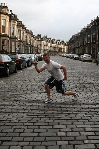
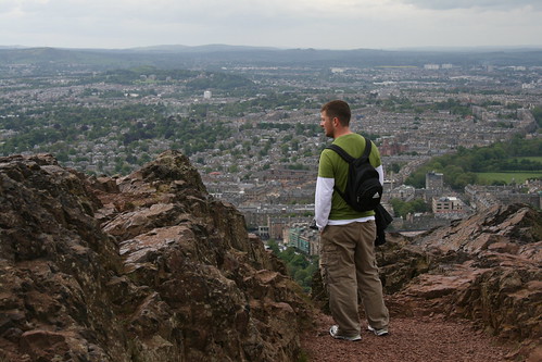
Now that I finally uploaded pictures from my trip to Scotland, I've spent some time trying to geotag photos on flickr.
It's certainly not as cool as the map featured last week, and I haven't geotagged all my pictures but I'm happy that my map is expanding.

Flickr's tool for geotagging pictures is pretty cool. You can edit in batch and then go add detail later. So for my Scotland pictures I initially have placed them all in one location. As I spend more time I'll be able to edit individual geotags to a more precise location, like I've done with this picture of Edinburgh Castle.
So, I'm looking forward to adding more and more detail to my map. It's an evolving kml file of the places I've been.
I think geotagging is emerging as an incredibly important component of not only photography, but also geography because it produces such great ways to view our world through the eyes of others. With that in mind, I encourage you to load your pictures on to flickr.com (its free, you know) and geotag them.
Monday, June 27, 2011
A World of Photography
I've posted before about the ever expanding globe of geotagged photos. I can see the wealth of images from around the world soon being turned into some sort of photosynth-meets-google-streetview image orgy. Until then we can sit back, relax and anticipate. Right?
While I've been a "pro" (meaning I pay money) member of flickr for a couple of years, I've never really used it. I wanted to make sure I had a "cloud" to store all my photos before we started using the term "cloud". Flickr certainly fit the bill, but until my recent full-fledged photography obsession, I never understood the flickr world. A week of looking around has taught me much about how to use it as a tool and clued me into the wealth of knowledge it includes.
The thought of turning one's experiences into an ever-evolving digital profile is something I've thought about a lot. I'm not talking about facebook, but more of a true fingerprint. Lots of people have privacy concerns - but whatever. Right at the top of the list of the cool personal experience widgets would be auto geotagged photos showing where you've been and for how long. I see it as the more classier version of this old blog widget.

Today as I was perusing flickr I stumbled upon this image Courtesy of Eric Fischer
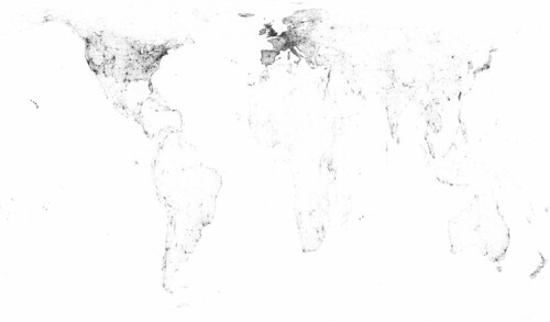
This is essentially a history of geotagged images. The darkest is the oldest, with the lighter shades being tagged more recently. It begs the question how many shades of grey are included. That would be a good follow up question but I already asked one question of Eric - where did you get the data? The data was assembled from flickr and the picassa API. What's cool is that I was pretty sure the data was from those API's. What's frustrating is I have zero programming experience and for the time being have to live vicariously through the API-harnessing abilities of people like Mr. Fischer.
Does this map remind you of anything else? This perhaps?
Be sure to check out the original size version on flickr. It's a heck of a map and an incredible set of data.
Subscribe to:
Posts (Atom)


