
A few recent posts have called into question the actions of the National Geographic Map Policy Committee.
Thanks to the helpful Kevin Lance of National Geographic Maps, I have the contact info for the Editorial and Research head in the Nat Geo Maps department, Juan Valdes. Yes, the coffee guy does maps too!
So far Nat Geo has been extremely accommodating. A big thumbs up to them! I'm excited to hear back from them.
After playing phone tag with Juan I sent him the following email:
Hi, Juan,
Thank you very much for your prompt response.
Kevin Lance referred me to you to answer a few questions regarding the reasoning/research behind a few areas on the National Geographic political maps.
1. What happened (on the ground) between 2001 (based on the world map) and 2007 (based on the Africa map) that changed ownership of the Hala'ib triangle from Sudan to Egypt? Also, why is Bir Tawil now shown as part of Sudan?
It appears the change now recognizes the 1899 border established by the 22nd parallel in place of the 1902 agreement the British put in place.
I know the Sudanese have pulled troops from the area and that Egypt has invested in the area.
In summary of question 1 - Why is the Hala'ib triangle now shown as part of Egypt and why is Bir Tawil shown as part of Sudan?
Question 2 - Why is Somaliland shown in grey on the continent political maps but not delineated at all on the world map?
National Geographic often discusses its desire to reflect what is on the ground and remain a-political. Somaliland recently elected a new president in a free and fare election as an opposition candidate. It seems the reality on the ground is that Somaliland is very much an autonomous State. The same cannot be said for Somalia. It seems that the only issue for showing Somaliland as part of Somalia is the lack of international recognition. Isn't recognition by other countries a political decision in itself?
In summary of question 2 - What is the research and reasoning for showing Somaliland in grey on Africa political maps and not at all on world maps?
I'll post Juan's response as soon as I get it.
To pass the time, why not take a peak at some of my pictures from Namibia.
Showing posts with label Somalia. Show all posts
Showing posts with label Somalia. Show all posts
Wednesday, August 25, 2010
Monday, July 19, 2010
Google Earth Image of the Week - July 19
I use Google Earth every single day. Its ever-changing wealth of information is intriguing and captivating. Today I'm launching the first weekly blog feature I've ever done, the Google Earth Image of the Week. Check back each Monday for a new image and discussion from around the world.
Today's image comes from a place I have been thinking (and talking) about a lot lately, Somaliland.

The highlighted area shows the location of a MiG jet in Freedom Square, Hargeisa. I know Somalia used its Air Force to bomb Hargeisa and areas of Somaliland, but I haven't found anything definitively identifying the jet in Freedom Square as a Somali jet shot down during the Civil War- which seems to be the most widely accepted rumor. If anyone has any info on the origins of the jet in Hargeisa, I'd appreciate you letting me know.
For reference, you can locate this area in Google Earth at 9° 33'41" N, 44° 3'55" E. Also for your reference (and my own) you can type the degrees symbol on a windows based computer by holding the alt key and typing 0176.
Today's image comes from a place I have been thinking (and talking) about a lot lately, Somaliland.
The highlighted area shows the location of a MiG jet in Freedom Square, Hargeisa. I know Somalia used its Air Force to bomb Hargeisa and areas of Somaliland, but I haven't found anything definitively identifying the jet in Freedom Square as a Somali jet shot down during the Civil War- which seems to be the most widely accepted rumor. If anyone has any info on the origins of the jet in Hargeisa, I'd appreciate you letting me know.
For reference, you can locate this area in Google Earth at 9° 33'41" N, 44° 3'55" E. Also for your reference (and my own) you can type the degrees symbol on a windows based computer by holding the alt key and typing 0176.
Monday, July 5, 2010
Imagining Somaliland
I've been watching a lot of the show Pawn Stars on the History Channel lately. My favorite guest expert on the show is Sean Rich, who specializes in antique arms and armor. He eloquently discusses his interest in antique arms in terms of imagining who it was to have held a gun or what someone must have been thinking when striking a blade to another blade in combat during the Civil War. Sean says that each weapon has a story to tell. That same thought, wonder and imagination is one of the reasons I'm so fascinated by maps. Each little tiny dot with a name next to it represents not just a city, but a place - with residents, history, landmarks and a story to tell. A world map is of particular interest because one can view the spatial relationship of all of these places at one time.
A place with an intriguing story to tell is Somalia, which, on July 1st celebrated its 50th anniversary of independence. Strife has plagued the young country for much of its existence following its independence from Britain. Today it is arguably the most unstable place on earth. Despite its strategic location on the horn of Africa, the gulf of Aden and serving as the entry point to the red sea and the Suez canal, the country ranks 224th in per capita GDP.
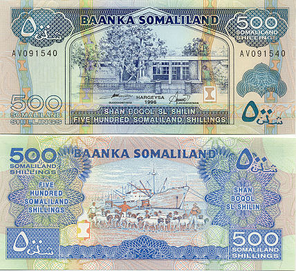
The northern reaches of what is recognizes internationally as Somalia, Somaliland, declared independence from Somalia in 1991. In an effort to build an economy and gain international recognition as an independent State, they began printing their own currency in 1994, the Somaliland Shilling. The release of the currency coincided with the elimination of the Somali Shilling as an accepted currency in Somaliland.
After a little research I became interested in obtaining some Somaliland currency. To my surprise I was able to find Somaliland shillings for sale. I used what the transformers use to find rare artifacts...ebay. I purchased a 500 shilling note from Robert at Robertsworldmoney.com. If you're looking to purchase foreign currency check out Robert's site. He has a wonderful collection of uncirculated currency. He also is a very kind salesman and is one of the very few who has been able to successfully blend hobby and business.
Here is an example of the 500 Somaliland Shilling note. They really are beautiful and one wonders how they are able to print something of such quality with a value of less than a dime.
 Despite the lack of international recognition as a State, Somaliland appears to be a beautiful place in its own right. Check out a great collection of images from Somaliland.
More to come on Somaliland's quest for recognition.
A place with an intriguing story to tell is Somalia, which, on July 1st celebrated its 50th anniversary of independence. Strife has plagued the young country for much of its existence following its independence from Britain. Today it is arguably the most unstable place on earth. Despite its strategic location on the horn of Africa, the gulf of Aden and serving as the entry point to the red sea and the Suez canal, the country ranks 224th in per capita GDP.
The northern reaches of what is recognizes internationally as Somalia, Somaliland, declared independence from Somalia in 1991. In an effort to build an economy and gain international recognition as an independent State, they began printing their own currency in 1994, the Somaliland Shilling. The release of the currency coincided with the elimination of the Somali Shilling as an accepted currency in Somaliland.
After a little research I became interested in obtaining some Somaliland currency. To my surprise I was able to find Somaliland shillings for sale. I used what the transformers use to find rare artifacts...ebay. I purchased a 500 shilling note from Robert at Robertsworldmoney.com. If you're looking to purchase foreign currency check out Robert's site. He has a wonderful collection of uncirculated currency. He also is a very kind salesman and is one of the very few who has been able to successfully blend hobby and business.
Here is an example of the 500 Somaliland Shilling note. They really are beautiful and one wonders how they are able to print something of such quality with a value of less than a dime.
Despite the lack of international recognition as a State, Somaliland appears to be a beautiful place in its own right. Check out a great collection of images from Somaliland. More to come on Somaliland's quest for recognition.
Subscribe to:
Posts (Atom)


