
In the process of writing a post questioning National Geographic Map Policy I was given the name of the Director of Editorial and Research for National Geographic Maps. I emailed him with a few questions on current map policy, specifically related to the Hala'ib triangle, Bir Tawil and Somaliland.
Today I heard back from Juan. As promised, his email is below. It's nothing groundbreaking and if I'm honest, predictable, but it speaks to the map giant's ability to respond to the public. I don't totally buy the fact that the scale of the maps prevents them from displaying Somaliland in grey, then again I only buy large maps and so my view might be a bit skewed. There doesn't seem to be any problem displaying Andorra and it is about the size of a pinhead on my 110" wide world map.
Thanks go out to Juan Valdes and Kevin Lance!
Ryan:
Thank you for your email of August 25, 2010 regarding the National Geographic's portrayal of the Hala'ib Triangle, Bir Tawil trapezoid, and Somaliland in our maps.
The Society’s cartographic policy is one of portraying de facto situations; that is, to portray to the best of our judgment the reality on the ground. We consult with multiple authoritative sources on a frequent basis to determine the current political status of disputed territories and how to best represent them in our maps.
With regard to our cartographic treatment of the Hala'ib Triangle, after several military clashes between Egyptian and Sudanese forces in the 1990's, Sudan ultimately withdrew from this area in January 2000. Their forces were pulled south of the political boundary set by the Anglo-Egyptian Agreement of 1899 - the 22nd parallel. Since then, Egypt has effectively administered the area.
As for the Bir Tawil trapezoid, Egypt does not recognize sovereignty over this area on its maps; here, it claims the 22nd parallel as both its political and administrative boundary. Inversely, Sudan officially recognizes the boundary of Bir Tawil as that set by the British in 1902. However, Sudanese sources contradict this stance by cartographically portraying the Bir Tawil trapezoid as being partially administered by the states of River Nile and Red Sea.
To date, the political and military situation in the Hala'ib Triangle remains unchanged, while Egypt's and Sudan's stance on Bir Tawil has been somewhat cartographically defined. Therefore, the Society's Map Policy Committee has recognized Egypt's de facto administration of the Hala'ib Triangle and Sudan's de facto governance of the Bir Tawil trapezoid. As a point of reference, and where scale permits, the 1902 administrative boundary is delineated in our maps accompanied by a label identifying Sudan's existing claim to the Hala'ib Triangle.
Regarding the color fill treatment of Somaliland in our Africa Wall Map, most political boundaries depicted in our maps and Atlases are stable and uncontested. Those that are disputed receive a special treatment. Depending on the map's scale, such territories or separatist states are shown in a gray fill with their administrative centers depicted by an open bull's eye symbol.
Where scale permits, explanatory notes are added to explain the current political situation of such disputed territories.The difference you have noted between our treatment of Somaliland in our World map to that of our Africa wall map is a reflection of this policy.
Finally, yes, I have been a long standing member of the Society's Map Policy Committee.
Your interest in National Geographic maps is appreciated. Thank you for taking the time to write.
Juan José Valdés
Director of Editorial and Research
National Geographic Maps
Showing posts with label Somaliland. Show all posts
Showing posts with label Somaliland. Show all posts
Tuesday, August 31, 2010
Wednesday, August 25, 2010
Update: National Geographic Maps
A few recent posts have called into question the actions of the National Geographic Map Policy Committee.
Thanks to the helpful Kevin Lance of National Geographic Maps, I have the contact info for the Editorial and Research head in the Nat Geo Maps department, Juan Valdes. Yes, the coffee guy does maps too!
So far Nat Geo has been extremely accommodating. A big thumbs up to them! I'm excited to hear back from them.
After playing phone tag with Juan I sent him the following email:
Hi, Juan,
Thank you very much for your prompt response.
Kevin Lance referred me to you to answer a few questions regarding the reasoning/research behind a few areas on the National Geographic political maps.
1. What happened (on the ground) between 2001 (based on the world map) and 2007 (based on the Africa map) that changed ownership of the Hala'ib triangle from Sudan to Egypt? Also, why is Bir Tawil now shown as part of Sudan?
It appears the change now recognizes the 1899 border established by the 22nd parallel in place of the 1902 agreement the British put in place.
I know the Sudanese have pulled troops from the area and that Egypt has invested in the area.
In summary of question 1 - Why is the Hala'ib triangle now shown as part of Egypt and why is Bir Tawil shown as part of Sudan?
Question 2 - Why is Somaliland shown in grey on the continent political maps but not delineated at all on the world map?
National Geographic often discusses its desire to reflect what is on the ground and remain a-political. Somaliland recently elected a new president in a free and fare election as an opposition candidate. It seems the reality on the ground is that Somaliland is very much an autonomous State. The same cannot be said for Somalia. It seems that the only issue for showing Somaliland as part of Somalia is the lack of international recognition. Isn't recognition by other countries a political decision in itself?
In summary of question 2 - What is the research and reasoning for showing Somaliland in grey on Africa political maps and not at all on world maps?
I'll post Juan's response as soon as I get it.
To pass the time, why not take a peak at some of my pictures from Namibia.
Thursday, July 22, 2010
Will Kosovo's Quest Pave the Way for Somaliland?
 Another exciting piece of political and geographic history occurred today as the International Court of Justice ruled the independence of Kosovo was not a violation of international law. This is another critical step in Kosovo's path towards international recognition. It's natural to think that this is a step in the right direction for other States seeking to have their independence recognized like Abkhazia and Somaliland but this will not end up helping their cause in the slightest. It's all political BS.
 This is good news for the Kosovoan people (I should probalby say those seeking independence) but this ruling does little to change my negative view on the international community's shunning of Somaliland.
 Vice President Biden just reiterated the United States' "unwavering commitment to Kosovo's sovereignty and territorial integrity." KOSOVO's territorial integrity! Are you kidding, Joe? Does that mean we invoke the Monroe Doctrine only when it is convenient? If we're going to site territorial integrity, we can't HIDE behind it when LEGITIMATE claims surface.
 Feel free to argue with me the legitimacy of Somaliland's claim! Prove me wrong! This has nothing to do with the Organization of African Unity trying to keep the borders as they exist. Somaliland is breaking away from Somalia, NOT Italian Somaliland.
The US has spent BILLIONS of dollars working to form effective democracies overseas. However, when one emerges organically, despite little monetary support and being located next to (or part of) arguably the most unstable place on earth, the US refuses to recognize it. Africa has suffered from colonial borders and disinvestment for decades. Why can we not support a success story in such a strategic area? Let's get passed the Monroe Doctrine already! Oh wait, I forgot, Biden already said we get to pick and choose when we follow that Doctrine!
So while we've always hated Slobodan, we love our pirates and could care less about the growing presence of Al-Shabab in the horn of Africa!
Update: I came across a Serb Kosovo blog I thought I'd share with you. One great thing about the interweb is the ability to find other sides of a story!
Monday, July 19, 2010
Google Earth Image of the Week - July 19
I use Google Earth every single day. Its ever-changing wealth of information is intriguing and captivating. Today I'm launching the first weekly blog feature I've ever done, the Google Earth Image of the Week. Check back each Monday for a new image and discussion from around the world.
Today's image comes from a place I have been thinking (and talking) about a lot lately, Somaliland.

The highlighted area shows the location of a MiG jet in Freedom Square, Hargeisa. I know Somalia used its Air Force to bomb Hargeisa and areas of Somaliland, but I haven't found anything definitively identifying the jet in Freedom Square as a Somali jet shot down during the Civil War- which seems to be the most widely accepted rumor. If anyone has any info on the origins of the jet in Hargeisa, I'd appreciate you letting me know.
For reference, you can locate this area in Google Earth at 9° 33'41" N, 44° 3'55" E. Also for your reference (and my own) you can type the degrees symbol on a windows based computer by holding the alt key and typing 0176.
Today's image comes from a place I have been thinking (and talking) about a lot lately, Somaliland.
The highlighted area shows the location of a MiG jet in Freedom Square, Hargeisa. I know Somalia used its Air Force to bomb Hargeisa and areas of Somaliland, but I haven't found anything definitively identifying the jet in Freedom Square as a Somali jet shot down during the Civil War- which seems to be the most widely accepted rumor. If anyone has any info on the origins of the jet in Hargeisa, I'd appreciate you letting me know.
For reference, you can locate this area in Google Earth at 9° 33'41" N, 44° 3'55" E. Also for your reference (and my own) you can type the degrees symbol on a windows based computer by holding the alt key and typing 0176.
Tuesday, July 6, 2010
The Fight for International Recognition by Forgotten Countries
I think most people believe statehood is granted by some divine authoritative body, or perhaps by a pencil-pushing bureaucrat on the third floor of some office building in New York. The question "What makes a country a country?" is a fascinating one with a wide variety of vague and non-specific answers.
We toss around terms like international community, sovereignty, constitutive and declarative theories of statehood and recognition to help us define country status, but these terms are vague themselves. Even recognition and inclusion by the UN can't be used as a determining factor for statehood, unless it is being used to validate the actions of it's own members as those who can "grant" that status.
The Montevideo Convention put forth basic criteria for country status but many will tell you the Montevideo Convention is virtually useless by itself and promotes absurd claims of statehood. These people subscribe to the more declarative theory, relying on the diplomatic action of the big boys. It's hard to think of promoting independence, sovereignty or statehood as a bad thing. However, the international community seems hesitant to recognize new countries, despite many having met (arguably) all criteria set forth by deterministic conventions (I'm using the other definition of convention here) with the exception of multilateral diplomatic relations.
Countries who, to this point have legitimized each other, seem to have a greater desire to keep the group exclusive than to stick to the more common considerations for country status i.e. Matt Rosenburg's list and the Montevideo Convention, external recognition excepted. When you think of it that way, external recognition, in reality, is the only criteria that really matters.
I don't like to think that way.
Why does the international community stonewall legitimate claims to independence, such as Somaliland, Kosovo and Taiwan? I recently asked about.com's Geography editor, Matt Rosenberg WHY Somaliland and other countries in waiting are having so much difficulty. He is scheduled to have a blog post answering the question later this week.
The point is that there is so much gray area for places like, Israel, Palestine, Somaliland, Kosovo, Tibet, Abkhazia, South Ossetia, North Korea, South Korea, etcetera that perhaps there is a need to consider a different source for country status. For most of us the biggest consideration in whether or not a country is a country is if we can find it on a map. As a whole, we don't care about Pakistan's refusal to recognize Armenia; We care if Armenia is on a map.
Who better to entrust country status than the a-political map geniuses at the National Geographic Society? Nat Geo takes this issue very seriously, citing several sources in their Maps Policy including "the United Nations, the European Community (apparently Nat Geo needs to UPDATE it's map policy as the EC has been disbanded), as well as the policies of individual governmental entities; the Board on Geographic Names; recognized reference books such as encyclopedias, dictionaries, geographical dictionaries, atlases, independent academic texts and other similar sources".
At least their process feels analytical and not quantitative or arbitrary. However, Nat Geo has also shown their ability to quickly adapt (or bend), exemplified by the Map Committee's recent ruling on the Paracell "Don't call me China" Islands, following an online petition signed by more than 10,000.
David Miller, a map editor for National Geographic Maps provides a more simplistic explanation: "for independence bids to ultimately succeed, the government must control its territory, have the support of the people, and show stability over a certain period of time." Of course, if we went by THAT definition we wouldn't have many countries to map!
Citing the Kosovo example, Mr. Miller goes on to say in the National Geographic News article "We're preparing our digital maps and databases … to start showing [Kosovo] as an independent country..." However, that change has yet to show up on their maps.
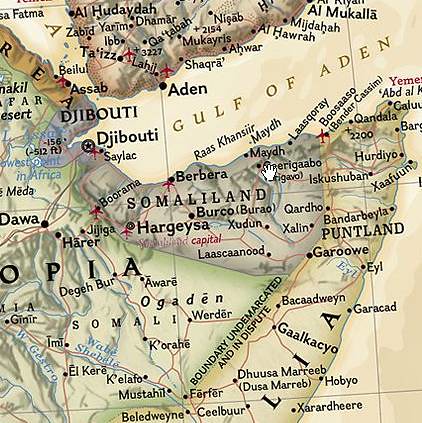
Interestingly enough, National Geographic seems to be wavering on the Somaliland issue. On continent maps Somaliland is delineated but not given a standard color, making clear the distinction that the "world" still sees Somaliland as an autonomous region of Somalia and not an independent country. On world maps, however, Somaliland is not delineated, only displayed similar to other states, such as Fezzan and Cyrenaica in Libya.
The discussion of country status is circular AT BEST. Really, when it comes down to it, there is no "official list", only opinions. A state's independence is real to anyone or anything who gives credence to it's existence.
We toss around terms like international community, sovereignty, constitutive and declarative theories of statehood and recognition to help us define country status, but these terms are vague themselves. Even recognition and inclusion by the UN can't be used as a determining factor for statehood, unless it is being used to validate the actions of it's own members as those who can "grant" that status.
The Montevideo Convention put forth basic criteria for country status but many will tell you the Montevideo Convention is virtually useless by itself and promotes absurd claims of statehood. These people subscribe to the more declarative theory, relying on the diplomatic action of the big boys. It's hard to think of promoting independence, sovereignty or statehood as a bad thing. However, the international community seems hesitant to recognize new countries, despite many having met (arguably) all criteria set forth by deterministic conventions (I'm using the other definition of convention here) with the exception of multilateral diplomatic relations.
Countries who, to this point have legitimized each other, seem to have a greater desire to keep the group exclusive than to stick to the more common considerations for country status i.e. Matt Rosenburg's list and the Montevideo Convention, external recognition excepted. When you think of it that way, external recognition, in reality, is the only criteria that really matters.
I don't like to think that way.
Why does the international community stonewall legitimate claims to independence, such as Somaliland, Kosovo and Taiwan? I recently asked about.com's Geography editor, Matt Rosenberg WHY Somaliland and other countries in waiting are having so much difficulty. He is scheduled to have a blog post answering the question later this week.
The point is that there is so much gray area for places like, Israel, Palestine, Somaliland, Kosovo, Tibet, Abkhazia, South Ossetia, North Korea, South Korea, etcetera that perhaps there is a need to consider a different source for country status. For most of us the biggest consideration in whether or not a country is a country is if we can find it on a map. As a whole, we don't care about Pakistan's refusal to recognize Armenia; We care if Armenia is on a map.
Who better to entrust country status than the a-political map geniuses at the National Geographic Society? Nat Geo takes this issue very seriously, citing several sources in their Maps Policy including "the United Nations, the European Community (apparently Nat Geo needs to UPDATE it's map policy as the EC has been disbanded), as well as the policies of individual governmental entities; the Board on Geographic Names; recognized reference books such as encyclopedias, dictionaries, geographical dictionaries, atlases, independent academic texts and other similar sources".
At least their process feels analytical and not quantitative or arbitrary. However, Nat Geo has also shown their ability to quickly adapt (or bend), exemplified by the Map Committee's recent ruling on the Paracell "Don't call me China" Islands, following an online petition signed by more than 10,000.
David Miller, a map editor for National Geographic Maps provides a more simplistic explanation: "for independence bids to ultimately succeed, the government must control its territory, have the support of the people, and show stability over a certain period of time." Of course, if we went by THAT definition we wouldn't have many countries to map!
Citing the Kosovo example, Mr. Miller goes on to say in the National Geographic News article "We're preparing our digital maps and databases … to start showing [Kosovo] as an independent country..." However, that change has yet to show up on their maps.
Interestingly enough, National Geographic seems to be wavering on the Somaliland issue. On continent maps Somaliland is delineated but not given a standard color, making clear the distinction that the "world" still sees Somaliland as an autonomous region of Somalia and not an independent country. On world maps, however, Somaliland is not delineated, only displayed similar to other states, such as Fezzan and Cyrenaica in Libya.
The discussion of country status is circular AT BEST. Really, when it comes down to it, there is no "official list", only opinions. A state's independence is real to anyone or anything who gives credence to it's existence.
Monday, July 5, 2010
Imagining Somaliland
I've been watching a lot of the show Pawn Stars on the History Channel lately. My favorite guest expert on the show is Sean Rich, who specializes in antique arms and armor. He eloquently discusses his interest in antique arms in terms of imagining who it was to have held a gun or what someone must have been thinking when striking a blade to another blade in combat during the Civil War. Sean says that each weapon has a story to tell. That same thought, wonder and imagination is one of the reasons I'm so fascinated by maps. Each little tiny dot with a name next to it represents not just a city, but a place - with residents, history, landmarks and a story to tell. A world map is of particular interest because one can view the spatial relationship of all of these places at one time.
A place with an intriguing story to tell is Somalia, which, on July 1st celebrated its 50th anniversary of independence. Strife has plagued the young country for much of its existence following its independence from Britain. Today it is arguably the most unstable place on earth. Despite its strategic location on the horn of Africa, the gulf of Aden and serving as the entry point to the red sea and the Suez canal, the country ranks 224th in per capita GDP.
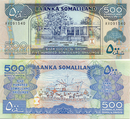
The northern reaches of what is recognizes internationally as Somalia, Somaliland, declared independence from Somalia in 1991. In an effort to build an economy and gain international recognition as an independent State, they began printing their own currency in 1994, the Somaliland Shilling. The release of the currency coincided with the elimination of the Somali Shilling as an accepted currency in Somaliland.
After a little research I became interested in obtaining some Somaliland currency. To my surprise I was able to find Somaliland shillings for sale. I used what the transformers use to find rare artifacts...ebay. I purchased a 500 shilling note from Robert at Robertsworldmoney.com. If you're looking to purchase foreign currency check out Robert's site. He has a wonderful collection of uncirculated currency. He also is a very kind salesman and is one of the very few who has been able to successfully blend hobby and business.
Here is an example of the 500 Somaliland Shilling note. They really are beautiful and one wonders how they are able to print something of such quality with a value of less than a dime.
 Despite the lack of international recognition as a State, Somaliland appears to be a beautiful place in its own right. Check out a great collection of images from Somaliland.
More to come on Somaliland's quest for recognition.
A place with an intriguing story to tell is Somalia, which, on July 1st celebrated its 50th anniversary of independence. Strife has plagued the young country for much of its existence following its independence from Britain. Today it is arguably the most unstable place on earth. Despite its strategic location on the horn of Africa, the gulf of Aden and serving as the entry point to the red sea and the Suez canal, the country ranks 224th in per capita GDP.
The northern reaches of what is recognizes internationally as Somalia, Somaliland, declared independence from Somalia in 1991. In an effort to build an economy and gain international recognition as an independent State, they began printing their own currency in 1994, the Somaliland Shilling. The release of the currency coincided with the elimination of the Somali Shilling as an accepted currency in Somaliland.
After a little research I became interested in obtaining some Somaliland currency. To my surprise I was able to find Somaliland shillings for sale. I used what the transformers use to find rare artifacts...ebay. I purchased a 500 shilling note from Robert at Robertsworldmoney.com. If you're looking to purchase foreign currency check out Robert's site. He has a wonderful collection of uncirculated currency. He also is a very kind salesman and is one of the very few who has been able to successfully blend hobby and business.
Here is an example of the 500 Somaliland Shilling note. They really are beautiful and one wonders how they are able to print something of such quality with a value of less than a dime.
Despite the lack of international recognition as a State, Somaliland appears to be a beautiful place in its own right. Check out a great collection of images from Somaliland. More to come on Somaliland's quest for recognition.
Subscribe to:
Posts (Atom)


