Monday, January 10, 2011

A Peninsula Affair

On a day filled with map and crosshairs news, I thought it would be nice, rather, to touch on an old political hotbed of contention, Crimea. The Black Sea peninsula has been a valuable post for many hundreds of years.

On a weekend that truly passed by in the blink of an eye, I found myself, as I often do, engulfed by a Sunday morning History Channel special: Russia - Land of the Tsars.

History Channel does a good job incorporating maps into their documentaries. They are particularly good at using them to show advancement and retraction of empires. One scene from Sunday portrayed the Russian advancement on the Crimean peninsula, on the Black Sea in modern day Ukraine.

In addition to being a relaxing Sunday activity, the documentary got me wanting to get back in to War & Peace and reread Crime & Punishment. The desire to travel to Russia, or course, also remains.

Here's how Crimea appears on my 2000 National Geographic wall map. A map which, on what was otherwise a challenging day, served as a window of imagination and inspired creative thoughts.

IMAG0191

Monday, January 3, 2011

New Year, New Spirit, Same Old Problems

The new year has provided me a refreshed spirit. I have high hopes for what the new year will bring. I purchased plane tickets to England, continued my running regimen and enjoyed a few short days off of work. In Michigan, we welcomed a new Governor who is calling for a culture change; It's hard to go more than a few hours without hearing about new positive economic indicators and the US markets started the new year at highs not seen for years.

Unfortunately international news is not as encouraging. The post election turmoil in Côte d'Ivoire and the rumors of impending genocide serve as reminders of how good things are in the west. Really, it makes uprisings in Greece and France seem trivial.

And we find ourselves six days out from the South Sudan referendum on independence. I'm all about national self-determination and I'm pro-South Sudan independence but I cant help but worry about what will happen in the aftermath of the vote. From oil revenues to delineation, voter eligibility and race relations one is reminded of the challenges of democracy and sovereignty.

One area of concern in the news a lot as of late is the Abyei region. It is a complete microcosm of Sudan, exhibiting the same issues affecting the country.

More to come on what will be the biggest change in maps since the breakup of the Soviet Union.

Happy New Year!

Monday, December 27, 2010

Morogoro

As I mentioned before, making a lot of corrections in Google Map Maker can be a frustrating and tedious process. Despite that I still find myself going in and doing an edit here or there regularly.

I scrolled around the Tanzania base map and came across the City of Morogoro. Morogoro is situated at the base of a small mountain in Eastern Tanzania. I had lunch there a few years ago on the road between Iringa and Dar es Salaam.

I'm not sure when the imagery was updated, but about half the City now has clear imagery in Google Earth. Because the imagery is so clear, I was surprised to see that the only roads that have been added to Morogoro are the major highways. Nobody has worked on the area in Map Maker. For a project a bit more rewarding than realigning intersections in the generally well mapped Iringa, I started adding new roads, local roads, in Morogoro.

I've posted on the Google Map Maker forum my frustration that the majority of roads in Africa are classified incorrectly as paved. I'm using this opportunity to create a city and also try to do it the right way, with local roads classified as unpaved.

If you're interested in trying Google Map Maker out, I encourage you to participate in mapping the City of Morogoro in Tanzania. You can access the area on here on map maker.

There are plenty of roads to add and railroads to correctly align! Here is a snapshot of what I've worked on so far.

Morogoro, Tanzania

If you are working on mapping another area, leave a comment, let me know and I'll drop by and help!

Monday, December 20, 2010

Ten Months Until the 91st Anniversary of the Traffic Signal

A tid-bit came across facebook this morning saying that today was the anniversary of the first traffic light. It turns out that the statement was perhaps a bit of an exaggeration. Apparently there were traffic lights, at least of some form, even if they required a police operator, back in the 1860's. Today, December 20th, is the anniversary of the first, modern traffic signal, one designed for a full intersection and with the familiar green, amber, red tri-color configuration. Since that first modern traffic signal was installed in Detroit, I thought I'd share it with you.

The intersection of Michigan Ave and Woodward is marked by the policeman I added. In the first pic, from 2002, the streets still intersect with four corners.

Detroit 2002

A couple years later, however, the City redesigned the intersection which now circles around Campus Martius park.

Detroit 2010

And now the area where Michigan Ave and Woodward connect is Campus Martius. In the winter months, the City turns a portion of the park into a skating rink. Very New Yorkesque.

Campus Martius Park

Of course, as it turns out, facebook lied. Today is not the anniversary of the first tri-color signal. Apparently it was in October of 1920, not December 1920.

:)

Oh well. It's still cool to look back at pictures of the area before Campus Martius, even if we didn't learn anything new today.

Monday, December 13, 2010

Crowdsourced: Google Map Maker

Google encourages us all to become citizen cartographers and help map our world with Google Map Maker! Count me in! Truth be told, I've come across it several times before but was never able to make it function. Naturally, with a new tool called Map Maker I figured I was best suited to help update and verify information in the area I know most. As a default I would be zoomed in to an area I recognized based on the water features (near my home) but I couldn't add anything to the map. No matter what I tried, I couldn't add a restaurant, a road, a bike path...nothing.

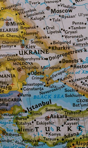
I don't recall exactly what brought me to the Google Map Maker tool most recently but I ended up editing a map of Iringa, Tanzania. If I can't do it for home, Iringa is one of my first "go-tos" for creating things geography and google related, and lets face it, Google map maker is about as close a match for that criteria as I'll ever find.

It might seem that the community maps in Africa as part of Google's effort to map Africa would need a lot of work, particularly outside of capital cities but several efforts by google have extended the accuracy of these user generated maps to much more rural areas. Well, perhaps smaller cities is more accurate. The Google Africa Blog talks about one of these efforts:Official Google Africa Blog: Mapping Korogocho. While there is some educational benefit that comes with trainings like this, in the end, Google is the big winner.

I was impressed by the accuracy of most of the roads in Iringa. All but a few outlying dirt roads were included and for the most part the accuracy matched up well with the satellite imagery.

While not as intuitive and arguably not as simple as Google's Building Maker, Map Maker offers much of the same fun factor. It is rewarding to know that you are contributing to a more completely and accurately mapped world that is more accessible to the masses than ever before.

That's the good.

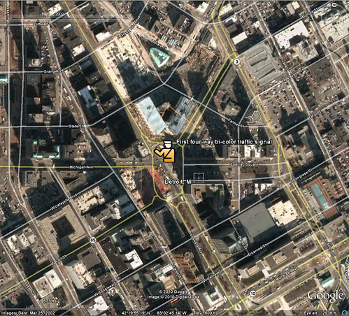
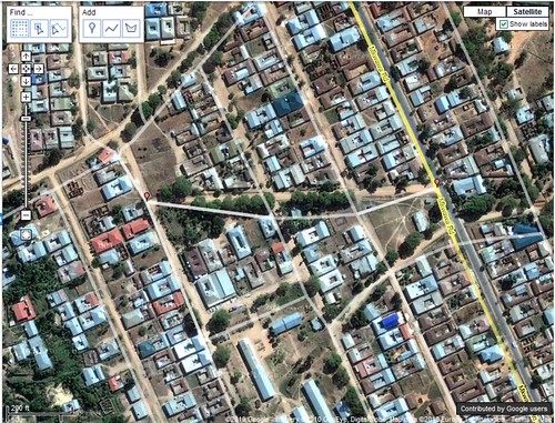
As I moved away from the center of Iringa I noticed that many of the roads are misaligned by 30-100 feet. Map maker does not let you do multi-editing which prevents you from aligning a segment of road. This means, you can fix the location of an intersection or you can fix the alignment of a road but you can't do both. Since there is no easy way to track a large number of edits in an area it becomes a fools errand (I'm not actually sure I'm using that idiom correctly, but it seems to fit) to try to fix misaligned roads- and there are a lot of them! So here I am complaining that I can't help Google for free, faster.

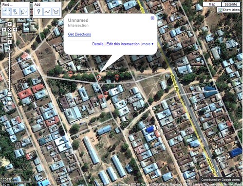
Here is an example where I fixed two intersections but was not able to fix the road (segment) connecting them because the segment had adjacent edits pending review. The two small red edit points are my approved edits. Noticed I arranged them based on the imagery. I could not edit the segment of road between these two edits at the same time.

map Maker

In order to complete the edit, I need to now fix the two remaining intersections...one at a time.

map maker edit

I have to hand it to Google. Much like building maker, they have crowdsourced some of the most detailed grunt-work to the world for no cost. Those U of M grads are really on to something with this Google thing.

As frustrating as actually making a lot of edits can be, I see myself doing a lot more with map maker, especially in Africa.

Monday, December 6, 2010

Carving Away the Dangerous Mountain

I have a few "go to" search phrases when I'm looking to get a good Youtube.com fix. While my favorite is probably "TV Bloopers", another that gets a frequent search from me is "Crazy Airport Landing". It's a good way to familiarize oneself with some famous, or rather infamous international airports.

This past weekend the History Channel replayed a show they produced called Most Extreme Airports which ranked the top 10 "MOST EXTREME" airports.

It was a fascinating show and I recognized several of the airports from youtube, most notably St. Maarten and Toncontin in Tegucigalpa.

I've included my favorite video from St. Maarten and Toncontin below.

St. Maarten


Toncontin


For reference, here is the list of the ten most extreme airports as ranked by the History Channel.

10. KSAN - San Diego, CA
9. LPMA - Madeira, Portugal
8. KEGE - Vail, CO
7. LFLJ - Courchevel, France
6. VHHH - Hong Kong Kai Tak
5. LXGB - Gibraltar
4. TNCM - St. Maarten
3. TFFJ - St. Barth's
2. MHTG - Tegucigalpa, Honduras
1. VNLK - Lukla, Nepal

I had read that improvements had been made at Toncontin which extended the runway and carved out a piece of the mountain for approaches from the south. I took to Google Earth to look at the change over time. It's pretty cool to see the south west portion of the landing stip before and after the safety improvements.

Toncontin before


Toncontin after


Time to add Tegucigalpa to the ever growing vacation list!