Showing posts with label Tanzania. Show all posts

Monday, December 27, 2010

Morogoro

As I mentioned before, making a lot of corrections in Google Map Maker can be a frustrating and tedious process. Despite that I still find myself going in and doing an edit here or there regularly.

I scrolled around the Tanzania base map and came across the City of Morogoro. Morogoro is situated at the base of a small mountain in Eastern Tanzania. I had lunch there a few years ago on the road between Iringa and Dar es Salaam.

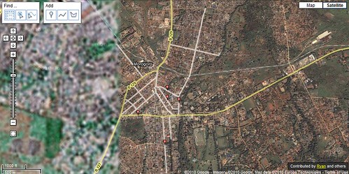
I'm not sure when the imagery was updated, but about half the City now has clear imagery in Google Earth. Because the imagery is so clear, I was surprised to see that the only roads that have been added to Morogoro are the major highways. Nobody has worked on the area in Map Maker. For a project a bit more rewarding than realigning intersections in the generally well mapped Iringa, I started adding new roads, local roads, in Morogoro.

I've posted on the Google Map Maker forum my frustration that the majority of roads in Africa are classified incorrectly as paved. I'm using this opportunity to create a city and also try to do it the right way, with local roads classified as unpaved.

If you're interested in trying Google Map Maker out, I encourage you to participate in mapping the City of Morogoro in Tanzania. You can access the area on here on map maker.

There are plenty of roads to add and railroads to correctly align! Here is a snapshot of what I've worked on so far.

Morogoro, Tanzania

If you are working on mapping another area, leave a comment, let me know and I'll drop by and help!

Friday, November 19, 2010

Little Black Dots on the Other Side of the World

Photo 1 - 2010-11-19
As a kid I was amazed by the multitude of cities and places found on maps or globes.  I wondered what Madagascar looked like and what the people who lived in Novosibirsk were like.  After seeing pictures of a place like Angel Falls on TV, I would go find it on a map and be intrigued that something so mammoth and enigmatic could be displayed by a tiny symbol.  Maps are filled with tiny black dots, each representing a city.   Those dots also represent the stories, history, and experiences of the people who live there.  Thinking of the millions of stories behind each tiny black dot on a map makes the world seem like an endless wonder of culture and geography.

Eventually for me, pictures and stories were not enough, and I found it was time for an adventure to one of these far-away places.  I wanted to have a better understanding of how life was different in one of those little black dots on the other side of the world and needed to go there to really experience it.

My curiosity led me to rural Tanzania, which seemed as far away – both physically and culturally – as I could get. With help from Global Volunteers, I was teamed up with a private school in rural Tanzania in the Village of Pommern, about two hours south of Iringa.  

While there, my assignment at the school entailed teaching computers and geography.  In preparation, I developed some basic lesson plans and even pulled a few things out of my old Computer Science book for class.  When I finally made it to the school after 17 hours worth of flying and nine hours of driving, I realized I was going to have to throw my lesson plans out the window and start from scratch.  

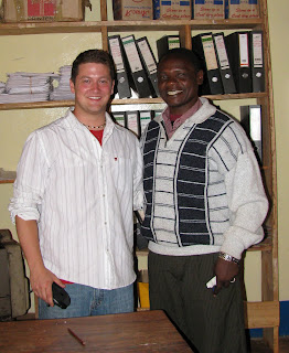
Growing up in a time and place where the computer has emerged as an indispensable tool, I didn’t expect the type of challenges I faced in Tanzania.  The West is a place where electronic technology is ubiquitous.  Even those who aren’t computer-savvy have been exposed to technology and used something like a telephone or a remote control.  This isn’t the case with most people in Tanzania.  We spent several full class periods working on the computer double-click – not the concept, the action.  The mouse was something so foreign that the children didn’t know what to make of it, or how to click it. Edward, my favorite teacher (pictured with me below), reminded me that repetition was key.  Thus rather than working on file management or word processing, I sat with each student and held their hand on the mouse and we double clicked for hours until they developed some muscle memory for the double-click.
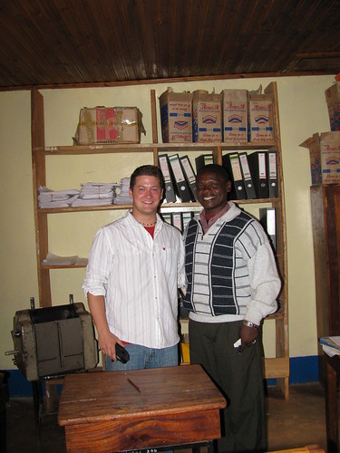
Picture 307

For the geography class, in addition to discussing topographic maps required by a national examination – yes, they even teach to the test in rural Tanzania – I wanted to discuss map distortions, a difficult but critical concept in understanding how we display a three-dimensional earth on a two-dimensional map. Trying to be as resourceful as I could, I used an old soccer ball I found, still smelling of the cow dung it had rolled through the day before on the soccer field. I used the soccer ball to help me illustrate map distortions by stretching the paper around the ball, showing how the paper itself became folded and distorted.  I then highlighted these areas of distortion by rubbing pencil graphite on the folds. As I straightened out the piece of paper, I looked around the room and could tell that at least the concept was beginning to click with them.  

While teaching presented unexpected challenges, it made me realize that these types of challenges were exactly the experiences I was seeking to help me develop a deeper understanding of the world.  Now, what appears to be just another small black dot on a world map to others has real meaning to me.  Behind that black dot is a story and an experience much larger than its symbol. Each time I look at the giant world map hung on my wall at home, I get excited looking at these black dots, because I know each represents another great adventure, and this keeps me excited about traveling this wonderful world.

View this post on My Wonderful World
 

Wednesday, August 18, 2010

Changing the Looking Glass: Radical Geography

Shape! Size! Distance!

The form 3 students in the tiny village of Pommern, Tanzania outside of Iringa repeated the mantra over and over. Edward, my favorite teacher (pictured with me below right) at the school reminded me that repetition was key to drilling anything new into the kids' heads.

Their exclamation was in response to my question. What are the main types of map distortions?!

Shape! Size! Distance!

Before the class started I found a scuffed up old soccer ball, still smelling of the cow dung it had rolled through the day before on the soccer field- excuse me-pitch!

I've always felt the best demonstration of map distortion was to use a ball and a piece of paper. I folded the paper around the ball to show how the page itself became distorted then highlighted those areas by rubbing pencil lead on the folds.

I straightened the paper to show the distortions when the sphere is projected in two dimensions. Some of the students understood but map projections can be one of the most difficult spatial issues to grasp; But it is paramount to understanding ones place and relative placement on the earth.

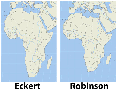
I remember as a child certain world maps making Africa look tall and skinny. Something didn't sit right with me when I saw that particular projection. It turns out that projection was an equal area projection like the Eckert IV shown in contrast with a Robinson projection in the image, left. The Robinson projection is easy on the eyes and just feels right.

Wouldn't you agree?

After a heads up from Matt Rosenberg in his post on the about.com site, I found a great website which uses radical map projections to view data in a new and exciting way.

Projections help us display the spheroid earth on a two dimensional surface. My favorite projection for world maps and the one used by the greats at national geographic is the Winkel tripel projection, a variation on the Robinson projection.

In one post ten projections are layered on each other to show the variations.

Since I mentioned National Geographic I'm excited to tell you that I have received an initial response from the company regarding my inquiries to the map policy committee as well as the Hala'ib triangle. I'll be sure to update you on what I ultimately discover.

I really hope you check out some of the amazing maps at radicalgeography.com.