
Two weeks ago, my nerd project focused on the dramatic change a divided Sudan will have on world maps. Because National Geographic is the be-all and end-all of quality maps (in my world), I used a snapshot from their iPad app and created a modified map from it to impress upon readers the dramatic change that will result.
When I finished my modified map, I contacted National Geographic to see if the Map Policy Committee had taken any action on South Sudan or if there were any updates as to how National Geographic plans to depict South Sudan. Always helpful, Juan Valdes replied. It turns out, a lot of thought has been given to South Sudan.
"In recognition of Southern Sudan's new political standing, the Society's Map Policy Committee examined how this autonomous region should be portrayed on our maps. As Southern Sudan has yet to gain its independence, and following the Society's principles for recognizing semi-autonomous states, it has been decided that the region should be designated on our maps as an "Area of Special Status." Where scale permits, our maps will show Southern Sudan in a gray boundary band or gray fill. Final color designation will be discussed and determined when Southern Sudan nears its independence. Juba, the region's administrative center, will be identified by a special symbol.
Additionally, and where scale permits, the Sudanese region of Abyei will be recognized. Although its borders were left undefined in a 2005 peace deal, in July 2009 the Abyei Tribunal redrew this region's borders. The redrawn borders left most, but not all, of the region's Muslim population residing outside its boundaries, making it more likely that the majority of its population would vote to join the south. This region will, for now, be identified by a simple red boundary treatment and the use of the following note: 2009 Abyei Tribunal Decision Line."
Unforunately, still no Map Policy Committee meeting minutes, although I did send another email to Cindy Beidel about those...I'm not going to get my hopes up. NGS seem relatively tight lipped about things before they are made official, one once they are made official it's re-established that its officiality is based in policy. That sounds circular, I think it's rather clever.
I look forward to an update of the National Geographic World Map. As of today, neither the Executive or Political World or Continent maps have been updated on their iPad application.
It turns out National Geographic has a policy for modified maps, too. Apparently Mr. Valdes has taken a peak or two at my blog and asked that I include the following:
Map modified by Ryan Buck. Boundaries and names shown do not necessarily reflect the map policy of the National Geographic Society.
I, of course, instantly added the disclaimer and think National Geographic has taken a remarkably understanding course of action with my modified map. The fact that there was concern (and I use that term loosely) over confusion the map might cause, probably overstates my photoshop abilities. If nothing else, I got a shout out on Matt Rosenberg's (about.com) twitter account.
Monday, February 7, 2011
Monday, January 31, 2011
Africa in an Instant
Inspired by the Very Small Array map, the United States of Autocorrect, I set out to create a similar map for other locations in the world using Google Instant Search.
Naturally, I started with Africa.
After eliminating the insipid instant results, something even better began to materialize. The continent took shape as a collection of history, strife and misconception - but in words. The words appeared powerful and descriptive enough on their own that I decided to remove the borders. What resulted surprised me, a map I call Africa in an Instant.
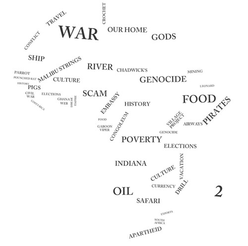
Click on the image above for the original large, high quality image.
Pretty cool!
Naturally, I started with Africa.
After eliminating the insipid instant results, something even better began to materialize. The continent took shape as a collection of history, strife and misconception - but in words. The words appeared powerful and descriptive enough on their own that I decided to remove the borders. What resulted surprised me, a map I call Africa in an Instant.
Click on the image above for the original large, high quality image.
Pretty cool!
Monday, January 24, 2011
Nerd Project: Political Map of South Sudan
There are a number of issues that still need to be resolved to fulfill the Comprehensive Peace Agreement, but the people have called for an independent South Sudan. To help visualize this dramatic change in geography and cartography I've created an... Improvised Political Map or IPM.
A couple weeks ago, I wrote that this would be the most noticeable change on the world map since the breakup of the Soviet Union. The IPM below clearly shows that to be the case.
The folks at National Geographic asked that I prevent any confusion by including the following:
Map modified by Ryan Buck. Boundaries and names shown do not necessarily reflect the map policy of the National Geographic Society.
The CPA requires that the details of the independence referendum be worked out by July 9 of this year. National Geographic won't be out with a map showing South Sudan until well after the details have been worked out but hopefully this improvisation will hold us Sudan map and geography hobbyists until then! I have emailed Juan Valdes from National Geographic Maps to get some "industry gossip" (if there is such a thing) on portraying South Sudan. I'll let you know what I hear.
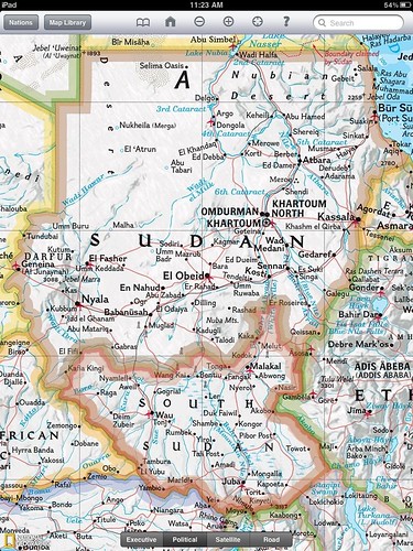
I employed some fairly "rudimentary" tools to do this. It's not perfect but it serves its purpose - to show us how different Sudan will look on a political map. The map is an edited copy of a screenshot from the National Geographic iPad app. In case my map has fooled you, National Geographic currently shows Sudan as below.

Perhaps the greatest challenge was picking a color. South Sudan will border six different countries, Sudan, Central African Republic, DRC, Uganda, Kenya and Ethiopia. National Geographic only uses six colors on their political maps which means I couldn't create a South Sudan border without copying another color. You might notice I sort of blended the border color with Kenya. That's fitting given the Ilemi Triangle issue.
I was having a hard time figuring out how National Geographic would color seven countries with six colors. It wasn't until a conversation at work that I realized the issue was my inability to change the color of the bordering countries which was the actual limiting factor. Fast fact - a Google search following that realization taught me (haha... "a Google search taught me") China borders more countries than any other.
I think it's time to email my old South Sudanese penpal Rengo Gyyw Rengo Jr!
It turns out Google is on the move to update and create maps of South Sudan
If you liked this post don't forget to check out other nerd projects.
A couple weeks ago, I wrote that this would be the most noticeable change on the world map since the breakup of the Soviet Union. The IPM below clearly shows that to be the case.
The folks at National Geographic asked that I prevent any confusion by including the following:
Map modified by Ryan Buck. Boundaries and names shown do not necessarily reflect the map policy of the National Geographic Society.
The CPA requires that the details of the independence referendum be worked out by July 9 of this year. National Geographic won't be out with a map showing South Sudan until well after the details have been worked out but hopefully this improvisation will hold us Sudan map and geography hobbyists until then! I have emailed Juan Valdes from National Geographic Maps to get some "industry gossip" (if there is such a thing) on portraying South Sudan. I'll let you know what I hear.
I employed some fairly "rudimentary" tools to do this. It's not perfect but it serves its purpose - to show us how different Sudan will look on a political map. The map is an edited copy of a screenshot from the National Geographic iPad app. In case my map has fooled you, National Geographic currently shows Sudan as below.
Perhaps the greatest challenge was picking a color. South Sudan will border six different countries, Sudan, Central African Republic, DRC, Uganda, Kenya and Ethiopia. National Geographic only uses six colors on their political maps which means I couldn't create a South Sudan border without copying another color. You might notice I sort of blended the border color with Kenya. That's fitting given the Ilemi Triangle issue.
I was having a hard time figuring out how National Geographic would color seven countries with six colors. It wasn't until a conversation at work that I realized the issue was my inability to change the color of the bordering countries which was the actual limiting factor. Fast fact - a Google search following that realization taught me (haha... "a Google search taught me") China borders more countries than any other.
I think it's time to email my old South Sudanese penpal Rengo Gyyw Rengo Jr!
It turns out Google is on the move to update and create maps of South Sudan
If you liked this post don't forget to check out other nerd projects.
Monday, January 17, 2011
Florida, Hawaii, Southeast Michigan and the Assassin's Creed or How I Spent My MLK Day
Southeast Michigan is a lonely place these days. My parents are in Florida, my girlfriend is in Hawaii and I am fending for myself on a three day weekend. It's not all bad though. I got a great 10 mile run in on Saturday. The snow made the run particularly challenging. Each step involved a little bit of a slip on the snow and ice and extended my run by about 10 minutes (and a few hundred calories). An hour and a half in 20 degree temps certainly makes one feel isolated and for the portion of my run in the back roads of the area, that feeling of isolation was very real, and great. :)
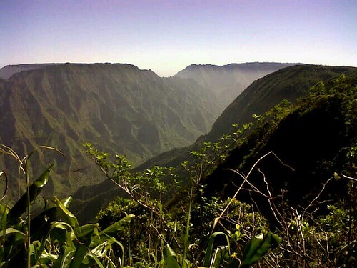
On the other end of the weather spectrum, take a gander at this pic my girlfriend just sent me.
And...back to reality.
On holidays, I usually try to watch a show to learn a little more about why I have the day off. That didn't quite work out today because I had a two hour special on Andrew Jackson I had recorded on the DVR. So, instead of a special on MLK, I learned quite a bit about the down side of Jackson and the removal of Indians. Bringing this post back to geography, it was interesting to learn about the impact geography had on two famous Jackson battles, The Battle of Horseshoe Bend and the Battle of New Orleans. Using land for a strategic advantage is as old as war but, for me, this was a great reminder of how Geography shows up every day in our lives.
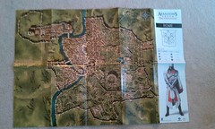
Everyone being out of town does give me a little time to spend on hobbies, research, reflection and of course, VIDEO GAMES! I went with Assassin's Creed Brotherhood. I was particularly intrigued by the map of the Roman world included in the official guide. You might think of guidebooks as cheating, I think of them as a way to fully immerse oneself in a game, and in this case, a new world. With a couple of hours in the books, the expansive world the game is played in is quite entertaining. The game does a great job at incorporating monuments, areas and characters inspired by real life.
Here's the map that lured me in!
On the other end of the weather spectrum, take a gander at this pic my girlfriend just sent me.
And...back to reality.
On holidays, I usually try to watch a show to learn a little more about why I have the day off. That didn't quite work out today because I had a two hour special on Andrew Jackson I had recorded on the DVR. So, instead of a special on MLK, I learned quite a bit about the down side of Jackson and the removal of Indians. Bringing this post back to geography, it was interesting to learn about the impact geography had on two famous Jackson battles, The Battle of Horseshoe Bend and the Battle of New Orleans. Using land for a strategic advantage is as old as war but, for me, this was a great reminder of how Geography shows up every day in our lives.
Everyone being out of town does give me a little time to spend on hobbies, research, reflection and of course, VIDEO GAMES! I went with Assassin's Creed Brotherhood. I was particularly intrigued by the map of the Roman world included in the official guide. You might think of guidebooks as cheating, I think of them as a way to fully immerse oneself in a game, and in this case, a new world. With a couple of hours in the books, the expansive world the game is played in is quite entertaining. The game does a great job at incorporating monuments, areas and characters inspired by real life.
Here's the map that lured me in!
Monday, January 10, 2011
A Peninsula Affair
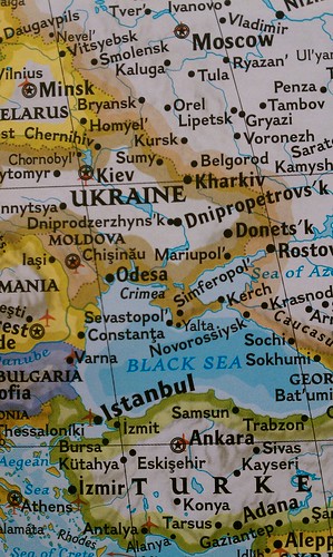
On a day filled with map and crosshairs news, I thought it would be nice, rather, to touch on an old political hotbed of contention, Crimea. The Black Sea peninsula has been a valuable post for many hundreds of years.
On a weekend that truly passed by in the blink of an eye, I found myself, as I often do, engulfed by a Sunday morning History Channel special: Russia - Land of the Tsars.
History Channel does a good job incorporating maps into their documentaries. They are particularly good at using them to show advancement and retraction of empires. One scene from Sunday portrayed the Russian advancement on the Crimean peninsula, on the Black Sea in modern day Ukraine.
In addition to being a relaxing Sunday activity, the documentary got me wanting to get back in to War & Peace and reread Crime & Punishment. The desire to travel to Russia, or course, also remains.
Here's how Crimea appears on my 2000 National Geographic wall map. A map which, on what was otherwise a challenging day, served as a window of imagination and inspired creative thoughts.
Monday, January 3, 2011
New Year, New Spirit, Same Old Problems
The new year has provided me a refreshed spirit. I have high hopes for what the new year will bring. I purchased plane tickets to England, continued my running regimen and enjoyed a few short days off of work. In Michigan, we welcomed a new Governor who is calling for a culture change; It's hard to go more than a few hours without hearing about new positive economic indicators and the US markets started the new year at highs not seen for years.
Unfortunately international news is not as encouraging. The post election turmoil in Côte d'Ivoire and the rumors of impending genocide serve as reminders of how good things are in the west. Really, it makes uprisings in Greece and France seem trivial.
And we find ourselves six days out from the South Sudan referendum on independence. I'm all about national self-determination and I'm pro-South Sudan independence but I cant help but worry about what will happen in the aftermath of the vote. From oil revenues to delineation, voter eligibility and race relations one is reminded of the challenges of democracy and sovereignty.
One area of concern in the news a lot as of late is the Abyei region. It is a complete microcosm of Sudan, exhibiting the same issues affecting the country.
More to come on what will be the biggest change in maps since the breakup of the Soviet Union.
Happy New Year!
Subscribe to:
Posts (Atom)


